|
|
|||||||||||||||||
| Point ID: 6636 | Downloads | Plots | Site Data | Code: 9445 |
|
|
|||||||||||||||||
| Download | |
|---|---|
| Site Descriptor Information | Site Time Series Data |
| Link to all available data | |
|
|
| View: | Statistics | Time Series |
| Units: | m3/s |
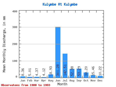
| Statistic | Jan | Feb | Mar | Apr | May | Jun | Jul | Aug | Sep | Oct | Nov | Dec | Annual |
|---|---|---|---|---|---|---|---|---|---|---|---|---|---|
| Mean | 8.35 | 5.05 | 4.36 | 4.12 | 18.92 | 301.28 | 142.49 | 52.37 | 53.29 | 30.20 | 15.46 | 10.22 | 642.18 |
| Standard Deviation | 3.77 | 1.87 | 1.64 | 1.43 | 13.45 | 106.65 | 108.89 | 19.75 | 22.67 | 17.04 | 4.04 | 3.25 | 143.06 |
| Min | 5.15 | 2.50 | 2.71 | 2.61 | 4.24 | 107.45 | 43.73 | 29.75 | 24.53 | 14.24 | 7.95 | 5.52 | 481.87 |
| Max | 15.68 | 8.49 | 7.70 | 6.73 | 44.07 | 450.32 | 380.51 | 100.00 | 90.23 | 75.34 | 21.00 | 16.53 | 857.32 |
| Coefficient of Variation | 0.45 | 0.37 | 0.38 | 0.35 | 0.71 | 0.35 | 0.76 | 0.38 | 0.42 | 0.56 | 0.26 | 0.32 | 0.22 |
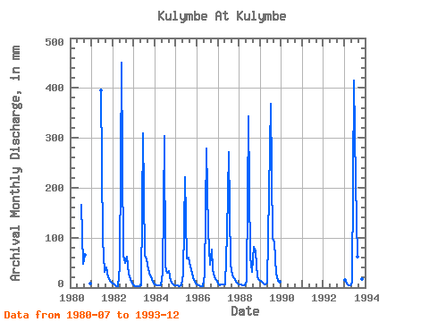
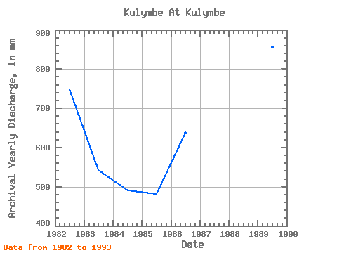
| Year | Jan | Feb | Mar | Apr | May | Jun | Jul | Aug | Sep | Oct | Nov | Dec | Annual | 1980 | 171.19 | 48.39 | 65.37 | 8.81 | 1981 | 395.36 | 99.15 | 32.63 | 40.11 | 21.44 | 14.03 | 10.25 | 1982 | 7.48 | 3.81 | 2.71 | 2.70 | 44.07 | 450.32 | 68.14 | 51.27 | 61.93 | 27.97 | 16.32 | 7.82 | 748.87 | 1983 | 5.15 | 2.50 | 2.97 | 2.61 | 4.24 | 309.24 | 68.31 | 58.81 | 37.40 | 24.66 | 16.16 | 9.24 | 543.73 | 1984 | 6.54 | 4.32 | 3.84 | 4.07 | 30.76 | 303.49 | 43.73 | 29.75 | 33.88 | 14.24 | 7.95 | 5.52 | 491.13 | 1985 | 5.51 | 3.50 | 3.25 | 3.87 | 26.27 | 220.65 | 59.92 | 62.80 | 42.16 | 27.80 | 15.99 | 9.24 | 481.87 | 1986 | 6.14 | 5.05 | 3.67 | 3.19 | 25.85 | 278.07 | 116.95 | 47.63 | 76.37 | 37.20 | 21.00 | 15.25 | 637.77 | 1987 | 7.42 | 4.78 | 6.07 | 6.14 | 6.65 | 107.45 | 279.67 | 47.88 | 24.53 | 18.56 | 11.07 | 7.96 | 524.04 | 1988 | 7.36 | 5.85 | 5.08 | 3.63 | 13.30 | 342.87 | 62.03 | 32.80 | 82.03 | 75.34 | 20.92 | 16.53 | 670.98 | 1989 | 13.90 | 8.49 | 7.70 | 6.73 | 9.32 | 191.12 | 380.51 | 100.00 | 90.23 | 28.39 | 13.70 | 12.03 | 857.32 | 1993 | 15.68 | 7.17 | 4.00 | 4.10 | 9.83 | 414.23 | 217.80 | 64.15 | 32.24 | 26.36 | 17.47 | 9.75 | 823.96 |
|---|
 Return to R-Arctic Net Home Page