|
|
|||||||||||||||||
| Point ID: 6636 | Downloads | Plots | Site Data | Code: 9445 |
|
|
|||||||||||||||||
| Download | |
|---|---|
| Site Descriptor Information | Site Time Series Data |
| Link to all available data | |
| View: | Time Series | All |
| Units: | mm |
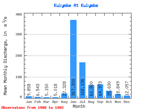
| Statistic | Jan | Feb | Mar | Apr | May | Jun | Jul | Aug | Sep | Oct | Nov | Dec | Annual |
|---|---|---|---|---|---|---|---|---|---|---|---|---|---|
| Mean | 9.86 | 6.54 | 5.15 | 5.02 | 22.33 | 367.30 | 168.14 | 61.80 | 64.97 | 35.63 | 18.85 | 12.06 | 64.30 |
| Standard Deviation | 4.45 | 2.43 | 1.93 | 1.74 | 15.87 | 130.02 | 128.49 | 23.31 | 27.64 | 20.11 | 4.92 | 3.83 | 14.32 |
| Min | 6.08 | 3.24 | 3.20 | 3.18 | 5.00 | 131.00 | 51.60 | 35.10 | 29.90 | 16.80 | 9.69 | 6.51 | 48.25 |
| Max | 18.50 | 11.00 | 9.09 | 8.20 | 52.00 | 549.00 | 449.00 | 118.00 | 110.00 | 88.90 | 25.60 | 19.50 | 85.84 |
| Coefficient of Variation | 0.45 | 0.37 | 0.38 | 0.35 | 0.71 | 0.35 | 0.76 | 0.38 | 0.42 | 0.56 | 0.26 | 0.32 | 0.22 |
 Return to R-Arctic Net Home Page