|
|
|||||||||||||||||
| Point ID: 6635 | Downloads | Plots | Site Data | Code: 9432 |
|
|
|||||||||||||||||
| Download | |
|---|---|
| Site Descriptor Information | Site Time Series Data |
| Link to all available data | |
| View: | Time Series | All |
| Units: | m3/s |
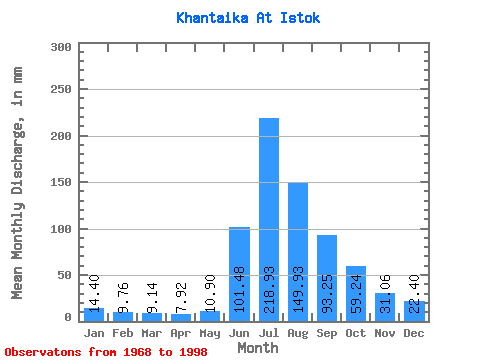
| Statistic | Jan | Feb | Mar | Apr | May | Jun | Jul | Aug | Sep | Oct | Nov | Dec | Annual |
|---|---|---|---|---|---|---|---|---|---|---|---|---|---|
| Mean | 14.40 | 9.85 | 9.14 | 7.92 | 10.90 | 101.47 | 218.90 | 149.91 | 93.25 | 59.23 | 31.06 | 22.40 | 717.83 |
| Standard Deviation | 23.19 | 19.77 | 20.90 | 18.23 | 21.01 | 32.71 | 45.36 | 64.96 | 32.79 | 23.04 | 22.86 | 25.90 | 201.62 |
| Min | 2.94 | 0.83 | 0.44 | 0.34 | 0.64 | 50.37 | 134.55 | 69.02 | 54.58 | 29.61 | 9.84 | 4.81 | 494.93 |
| Max | 126.28 | 105.73 | 112.78 | 98.41 | 112.13 | 167.53 | 317.88 | 311.35 | 200.41 | 114.52 | 121.59 | 140.21 | 1459.54 |
| Coefficient of Variation | 1.61 | 2.01 | 2.29 | 2.30 | 1.93 | 0.32 | 0.21 | 0.43 | 0.35 | 0.39 | 0.74 | 1.16 | 0.28 |
 Return to R-Arctic Net Home Page