|
|
|||||||||||||||||
| Point ID: 6635 | Downloads | Plots | Site Data | Code: 9432 |
|
|
|||||||||||||||||
| Download | |
|---|---|
| Site Descriptor Information | Site Time Series Data |
| Link to all available data | |
| View: | Time Series | All |
| Units: | mm |
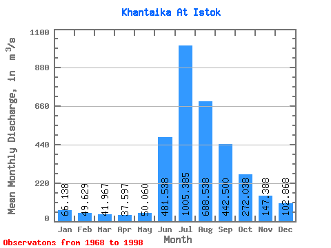
| Statistic | Jan | Feb | Mar | Apr | May | Jun | Jul | Aug | Sep | Oct | Nov | Dec | Annual |
|---|---|---|---|---|---|---|---|---|---|---|---|---|---|
| Mean | 66.14 | 49.63 | 41.97 | 37.60 | 50.06 | 481.54 | 1005.38 | 688.54 | 442.50 | 272.04 | 147.39 | 102.87 | 279.76 |
| Standard Deviation | 106.51 | 99.64 | 95.99 | 86.48 | 96.48 | 155.24 | 208.34 | 298.37 | 155.62 | 105.82 | 108.49 | 118.98 | 78.58 |
| Min | 13.50 | 4.19 | 2.04 | 1.61 | 2.92 | 239.00 | 618.00 | 317.00 | 259.00 | 136.00 | 46.70 | 22.10 | 192.89 |
| Max | 580.00 | 533.00 | 518.00 | 467.00 | 515.00 | 795.00 | 1460.00 | 1430.00 | 951.00 | 526.00 | 577.00 | 644.00 | 568.83 |
| Coefficient of Variation | 1.61 | 2.01 | 2.29 | 2.30 | 1.93 | 0.32 | 0.21 | 0.43 | 0.35 | 0.39 | 0.74 | 1.16 | 0.28 |
 Return to R-Arctic Net Home Page