|
|
|||||||||||||||||
| Point ID: 6635 | Downloads | Plots | Site Data | Code: 9432 |
|
|
|||||||||||||||||
| Download | |
|---|---|
| Site Descriptor Information | Site Time Series Data |
| Link to all available data | |
|
|
| View: | Statistics | Time Series |
| Units: | m3/s |
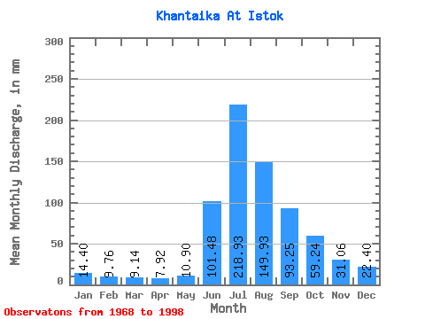
| Statistic | Jan | Feb | Mar | Apr | May | Jun | Jul | Aug | Sep | Oct | Nov | Dec | Annual |
|---|---|---|---|---|---|---|---|---|---|---|---|---|---|
| Mean | 14.40 | 9.85 | 9.14 | 7.92 | 10.90 | 101.47 | 218.90 | 149.91 | 93.25 | 59.23 | 31.06 | 22.40 | 717.83 |
| Standard Deviation | 23.19 | 19.77 | 20.90 | 18.23 | 21.01 | 32.71 | 45.36 | 64.96 | 32.79 | 23.04 | 22.86 | 25.90 | 201.62 |
| Min | 2.94 | 0.83 | 0.44 | 0.34 | 0.64 | 50.37 | 134.55 | 69.02 | 54.58 | 29.61 | 9.84 | 4.81 | 494.93 |
| Max | 126.28 | 105.73 | 112.78 | 98.41 | 112.13 | 167.53 | 317.88 | 311.35 | 200.41 | 114.52 | 121.59 | 140.21 | 1459.54 |
| Coefficient of Variation | 1.61 | 2.01 | 2.29 | 2.30 | 1.93 | 0.32 | 0.21 | 0.43 | 0.35 | 0.39 | 0.74 | 1.16 | 0.28 |
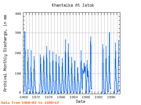
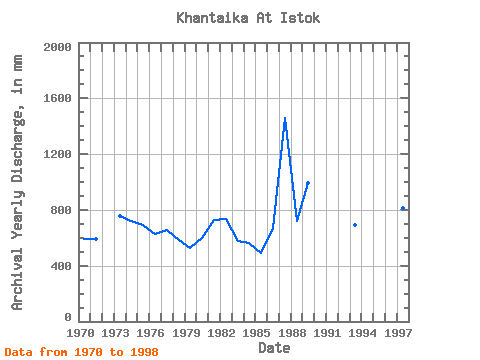
| Year | Jan | Feb | Mar | Apr | May | Jun | Jul | Aug | Sep | Oct | Nov | Dec | Annual | 1968 | 10.89 | 9.84 | 10.69 | 60.06 | 317.88 | 304.81 | 134.87 | 60.09 | 15.99 | 7.08 | 1969 | 3.18 | 0.83 | 0.44 | 0.34 | 0.64 | 99.04 | 226.43 | 145.00 | 92.30 | 53.78 | 24.66 | 1970 | 9.75 | 5.40 | 3.22 | 2.44 | 2.40 | 50.37 | 219.90 | 138.91 | 77.34 | 49.86 | 24.45 | 13.70 | 592.56 | 1971 | 9.84 | 5.24 | 4.31 | 3.56 | 3.85 | 61.74 | 190.07 | 148.05 | 81.97 | 47.68 | 24.23 | 18.09 | 594.02 | 1972 | 12.19 | 7.50 | 5.77 | 4.45 | 4.68 | 1973 | 3.46 | 3.06 | 3.11 | 2.91 | 6.07 | 88.72 | 199.44 | 169.17 | 126.23 | 86.44 | 46.15 | 23.95 | 754.00 | 1974 | 14.46 | 6.76 | 5.51 | 5.52 | 6.53 | 65.54 | 167.21 | 192.90 | 138.45 | 75.55 | 30.34 | 16.33 | 720.58 | 1975 | 11.63 | 6.29 | 5.01 | 3.62 | 4.64 | 152.36 | 241.67 | 121.05 | 65.75 | 48.34 | 22.55 | 14.80 | 693.76 | 1976 | 9.56 | 3.91 | 2.29 | 2.21 | 5.12 | 110.42 | 219.90 | 97.32 | 91.88 | 48.34 | 22.55 | 15.52 | 625.51 | 1977 | 10.97 | 7.12 | 5.42 | 4.30 | 6.53 | 117.17 | 213.15 | 120.40 | 77.55 | 51.16 | 25.29 | 18.22 | 653.50 | 1978 | 11.13 | 6.63 | 4.99 | 3.65 | 4.46 | 119.27 | 198.56 | 123.89 | 62.38 | 30.48 | 14.90 | 11.39 | 588.26 | 1979 | 6.58 | 2.52 | 1.40 | 1.11 | 1.28 | 113.16 | 190.51 | 82.95 | 54.58 | 45.72 | 19.81 | 14.35 | 530.79 | 1980 | 9.45 | 5.71 | 4.81 | 4.17 | 3.88 | 92.09 | 180.71 | 134.55 | 81.34 | 50.08 | 20.48 | 15.52 | 599.00 | 1981 | 12.15 | 8.75 | 7.18 | 6.01 | 6.49 | 153.20 | 274.33 | 133.47 | 63.01 | 31.79 | 19.85 | 16.29 | 728.10 | 1982 | 10.62 | 6.72 | 5.59 | 4.21 | 5.66 | 167.53 | 254.74 | 117.79 | 80.08 | 47.03 | 22.34 | 15.85 | 734.52 | 1983 | 10.34 | 6.76 | 5.97 | 5.18 | 5.59 | 74.81 | 185.50 | 120.18 | 76.28 | 47.03 | 24.66 | 15.94 | 574.43 | 1984 | 12.45 | 7.99 | 6.34 | 5.14 | 9.64 | 157.84 | 168.30 | 74.90 | 64.27 | 35.92 | 15.03 | 7.38 | 563.74 | 1985 | 5.75 | 4.30 | 4.01 | 3.67 | 7.92 | 122.86 | 134.55 | 69.02 | 62.38 | 47.90 | 21.07 | 13.15 | 494.93 | 1986 | 6.81 | 3.49 | 3.22 | 2.95 | 5.40 | 99.25 | 219.90 | 117.35 | 91.46 | 70.11 | 34.14 | 20.79 | 670.54 | 1987 | 126.28 | 105.73 | 112.78 | 98.41 | 112.13 | 110.21 | 155.89 | 151.75 | 118.85 | 107.12 | 121.59 | 140.21 | 1459.54 | 1988 | 9.01 | 5.43 | 4.81 | 3.94 | 5.88 | 123.91 | 169.39 | 88.18 | 84.08 | 114.52 | 69.96 | 42.89 | 718.78 | 1989 | 19.49 | 10.81 | 8.97 | 7.65 | 8.75 | 61.53 | 241.67 | 289.57 | 200.41 | 97.32 | 29.50 | 25.26 | 993.78 | 1993 | 5.46 | 3.67 | 3.61 | 5.52 | 11.26 | 58.37 | 250.38 | 203.35 | 99.04 | 40.71 | 9.84 | 4.81 | 689.55 | 1994 | 2.94 | 1.72 | 1.51 | 2.09 | 3.27 | 108.32 | 241.67 | 117.35 | 90.40 | 80.56 | 43.41 | 20.77 | 709.34 | 1995 | 13.52 | 11.13 | 11.50 | 9.84 | 10.52 | 83.03 | 300.46 | 311.35 | 142.46 | 70.11 | 34.35 | 28.09 | 1017.79 | 1997 | 8.45 | 5.34 | 3.46 | 3.90 | 31.79 | 92.30 | 259.09 | 173.53 | 84.50 | 72.72 | 55.63 | 31.57 | 815.75 | 1998 | 18.92 | 13.15 | 10.58 | 7.27 | 9.21 | 95.25 | 269.98 | 150.88 | 82.61 | 29.61 | 14.77 | 7.97 | 705.25 |
|---|
 Return to R-Arctic Net Home Page