|
|
|||||||||||||||||
| Point ID: 6631 | Downloads | Plots | Site Data | Code: 9422 |
|
|
|||||||||||||||||
| Download | |
|---|---|
| Site Descriptor Information | Site Time Series Data |
| Link to all available data | |
| View: | Time Series | All |
| Units: | m3/s |
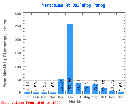
| Statistic | Jan | Feb | Mar | Apr | May | Jun | Jul | Aug | Sep | Oct | Nov | Dec | Annual |
|---|---|---|---|---|---|---|---|---|---|---|---|---|---|
| Mean | 6.13 | 4.62 | 4.55 | 4.65 | 55.79 | 257.93 | 39.43 | 29.61 | 36.43 | 22.55 | 10.76 | 7.67 | 483.19 |
| Standard Deviation | 2.28 | 1.75 | 1.60 | 1.41 | 47.55 | 90.06 | 20.86 | 14.94 | 16.82 | 7.89 | 4.08 | 2.99 | 78.37 |
| Min | 1.74 | 1.05 | 0.88 | 1.07 | 7.42 | 69.50 | 13.60 | 11.24 | 13.56 | 7.56 | 1.67 | 3.18 | 295.29 |
| Max | 12.54 | 9.81 | 7.24 | 7.69 | 223.07 | 475.68 | 105.35 | 78.87 | 81.18 | 40.32 | 20.34 | 14.86 | 651.32 |
| Coefficient of Variation | 0.37 | 0.38 | 0.35 | 0.30 | 0.85 | 0.35 | 0.53 | 0.51 | 0.46 | 0.35 | 0.38 | 0.39 | 0.16 |
 Return to R-Arctic Net Home Page