|
|
|||||||||||||||||
| Point ID: 6631 | Downloads | Plots | Site Data | Code: 9422 |
|
|
|||||||||||||||||
| Download | |
|---|---|
| Site Descriptor Information | Site Time Series Data |
| Link to all available data | |
| View: | Time Series | All |
| Units: | mm |
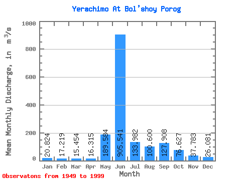
| Statistic | Jan | Feb | Mar | Apr | May | Jun | Jul | Aug | Sep | Oct | Nov | Dec | Annual |
|---|---|---|---|---|---|---|---|---|---|---|---|---|---|
| Mean | 20.82 | 17.22 | 15.45 | 16.32 | 189.58 | 905.54 | 133.98 | 100.60 | 127.91 | 76.63 | 37.78 | 26.08 | 139.32 |
| Standard Deviation | 7.74 | 6.55 | 5.43 | 4.94 | 161.59 | 316.18 | 70.88 | 50.78 | 59.04 | 26.82 | 14.31 | 10.15 | 22.60 |
| Min | 5.92 | 3.90 | 2.98 | 3.76 | 25.20 | 244.00 | 46.20 | 38.20 | 47.60 | 25.70 | 5.87 | 10.80 | 85.14 |
| Max | 42.60 | 36.60 | 24.60 | 27.00 | 758.00 | 1670.00 | 358.00 | 268.00 | 285.00 | 137.00 | 71.40 | 50.50 | 187.80 |
| Coefficient of Variation | 0.37 | 0.38 | 0.35 | 0.30 | 0.85 | 0.35 | 0.53 | 0.51 | 0.46 | 0.35 | 0.38 | 0.39 | 0.16 |
 Return to R-Arctic Net Home Page