|
|
|||||||||||||||||
| Point ID: 6631 | Downloads | Plots | Site Data | Code: 9422 |
|
|
|||||||||||||||||
| Download | |
|---|---|
| Site Descriptor Information | Site Time Series Data |
| Link to all available data | |
|
|
| View: | Statistics | Time Series |
| Units: | m3/s |
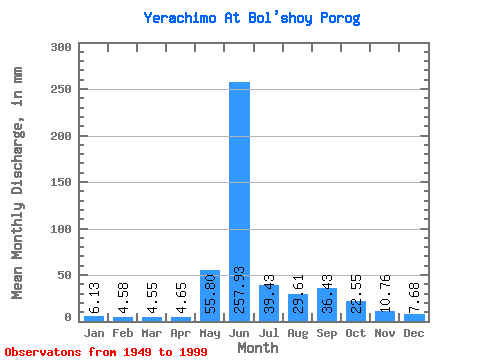
| Statistic | Jan | Feb | Mar | Apr | May | Jun | Jul | Aug | Sep | Oct | Nov | Dec | Annual |
|---|---|---|---|---|---|---|---|---|---|---|---|---|---|
| Mean | 6.13 | 4.62 | 4.55 | 4.65 | 55.79 | 257.93 | 39.43 | 29.61 | 36.43 | 22.55 | 10.76 | 7.67 | 483.19 |
| Standard Deviation | 2.28 | 1.75 | 1.60 | 1.41 | 47.55 | 90.06 | 20.86 | 14.94 | 16.82 | 7.89 | 4.08 | 2.99 | 78.37 |
| Min | 1.74 | 1.05 | 0.88 | 1.07 | 7.42 | 69.50 | 13.60 | 11.24 | 13.56 | 7.56 | 1.67 | 3.18 | 295.29 |
| Max | 12.54 | 9.81 | 7.24 | 7.69 | 223.07 | 475.68 | 105.35 | 78.87 | 81.18 | 40.32 | 20.34 | 14.86 | 651.32 |
| Coefficient of Variation | 0.37 | 0.38 | 0.35 | 0.30 | 0.85 | 0.35 | 0.53 | 0.51 | 0.46 | 0.35 | 0.38 | 0.39 | 0.16 |
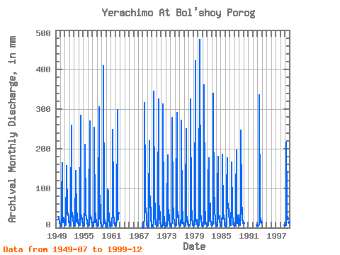
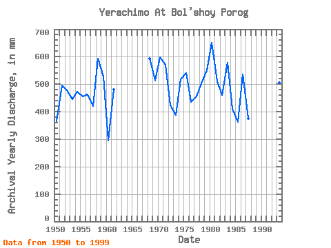
| Year | Jan | Feb | Mar | Apr | May | Jun | Jul | Aug | Sep | Oct | Nov | Dec | Annual | 1949 | 27.90 | 28.22 | 21.19 | 20.28 | 11.65 | 7.92 | 1950 | 7.15 | 2.23 | 2.65 | 4.19 | 70.63 | 164.06 | 29.72 | 14.13 | 13.98 | 27.02 | 16.15 | 12.54 | 364.58 | 1951 | 9.27 | 6.43 | 6.47 | 6.44 | 151.85 | 157.23 | 35.61 | 35.31 | 37.03 | 22.84 | 14.16 | 14.86 | 496.20 | 1952 | 12.54 | 9.81 | 6.74 | 5.24 | 45.61 | 258.92 | 28.57 | 30.31 | 37.88 | 22.16 | 12.13 | 6.21 | 478.78 | 1953 | 5.59 | 5.09 | 5.15 | 6.04 | 148.91 | 142.99 | 28.40 | 15.36 | 37.03 | 30.90 | 11.79 | 8.71 | 444.90 | 1954 | 8.83 | 6.19 | 6.53 | 6.12 | 20.31 | 284.83 | 40.61 | 23.25 | 31.05 | 19.60 | 14.13 | 9.56 | 474.12 | 1955 | 8.53 | 6.06 | 5.15 | 4.90 | 67.98 | 210.78 | 39.43 | 35.02 | 26.35 | 21.84 | 20.34 | 9.65 | 456.98 | 1956 | 9.09 | 6.14 | 5.53 | 5.61 | 26.87 | 270.59 | 32.08 | 22.78 | 30.19 | 24.84 | 17.03 | 8.42 | 462.07 | 1957 | 7.65 | 4.34 | 3.44 | 3.79 | 28.52 | 253.50 | 13.60 | 15.95 | 37.31 | 32.67 | 10.37 | 6.71 | 420.71 | 1958 | 6.39 | 5.90 | 5.86 | 4.70 | 51.21 | 304.77 | 23.43 | 50.32 | 81.18 | 36.20 | 13.42 | 6.68 | 593.20 | 1959 | 5.42 | 3.73 | 3.47 | 4.87 | 10.59 | 410.16 | 19.84 | 12.71 | 21.05 | 17.83 | 8.66 | 5.00 | 528.80 | 1960 | 3.06 | 1.63 | 1.05 | 1.53 | 100.35 | 91.43 | 18.45 | 37.08 | 20.02 | 12.30 | 4.61 | 5.09 | 295.29 | 1961 | 4.65 | 3.83 | 4.44 | 4.61 | 45.03 | 248.38 | 88.29 | 29.72 | 24.50 | 13.68 | 6.27 | 5.97 | 480.39 | 1962 | 5.74 | 5.34 | 6.00 | 5.01 | 22.84 | 299.08 | 22.93 | 20.84 | 37.60 | 1968 | 1.74 | 1.05 | 0.88 | 1.07 | 29.72 | 316.17 | 105.35 | 48.56 | 50.13 | 27.49 | 7.12 | 3.18 | 594.14 | 1969 | 2.17 | 1.70 | 1.42 | 2.09 | 57.97 | 219.61 | 58.86 | 52.97 | 80.04 | 25.19 | 6.21 | 3.27 | 512.52 | 1970 | 3.30 | 2.73 | 2.70 | 2.57 | 16.45 | 344.65 | 63.27 | 48.56 | 61.81 | 33.55 | 8.46 | 7.27 | 598.51 | 1971 | 6.59 | 5.42 | 4.65 | 4.16 | 60.92 | 324.71 | 35.31 | 21.28 | 55.54 | 29.19 | 11.45 | 8.98 | 571.43 | 1972 | 6.30 | 3.54 | 3.62 | 3.53 | 7.42 | 313.32 | 19.25 | 21.92 | 27.63 | 7.56 | 1.67 | 3.27 | 423.13 | 1973 | 4.36 | 4.00 | 4.77 | 4.67 | 43.26 | 184.57 | 36.79 | 19.42 | 46.14 | 21.04 | 9.12 | 7.21 | 386.78 | 1974 | 5.77 | 4.10 | 3.59 | 3.19 | 18.63 | 279.14 | 53.85 | 44.14 | 48.71 | 30.61 | 13.33 | 10.18 | 517.62 | 1975 | 7.33 | 5.04 | 5.18 | 5.53 | 60.03 | 290.53 | 58.86 | 26.16 | 30.19 | 31.49 | 10.62 | 9.18 | 541.92 | 1976 | 7.62 | 5.31 | 5.24 | 5.07 | 35.90 | 270.88 | 17.07 | 11.24 | 39.88 | 17.25 | 9.29 | 7.71 | 435.80 | 1977 | 6.65 | 4.91 | 4.53 | 4.96 | 73.28 | 249.52 | 42.97 | 15.33 | 23.95 | 13.60 | 7.52 | 6.97 | 455.83 | 1978 | 5.89 | 4.24 | 4.06 | 3.87 | 12.68 | 324.71 | 30.02 | 31.49 | 42.16 | 24.51 | 10.88 | 6.27 | 504.64 | 1979 | 5.42 | 4.45 | 4.56 | 4.27 | 7.50 | 421.56 | 25.25 | 17.04 | 19.08 | 20.78 | 8.37 | 6.83 | 550.54 | 1980 | 6.03 | 3.51 | 3.12 | 5.75 | 25.01 | 475.68 | 42.67 | 23.90 | 29.91 | 20.39 | 5.92 | 3.80 | 651.32 | 1981 | 3.35 | 3.86 | 4.59 | 4.47 | 7.53 | 361.74 | 70.04 | 14.48 | 13.56 | 8.24 | 8.37 | 6.62 | 510.80 | 1982 | 5.65 | 4.37 | 4.09 | 5.50 | 118.60 | 176.03 | 16.71 | 27.34 | 61.81 | 22.45 | 9.63 | 7.62 | 460.22 | 1983 | 6.83 | 6.09 | 6.53 | 6.24 | 11.04 | 338.95 | 40.61 | 78.87 | 37.88 | 25.69 | 13.10 | 3.44 | 578.46 | 1984 | 3.18 | 4.26 | 5.83 | 4.84 | 98.88 | 179.73 | 32.08 | 23.48 | 29.34 | 15.39 | 8.23 | 5.65 | 411.18 | 1985 | 4.36 | 3.00 | 4.09 | 5.30 | 47.97 | 184.86 | 27.96 | 23.95 | 32.19 | 15.98 | 6.61 | 4.53 | 362.07 | 1986 | 3.41 | 2.58 | 2.52 | 2.62 | 96.23 | 176.88 | 68.27 | 60.92 | 58.68 | 40.32 | 13.87 | 11.65 | 536.77 | 1987 | 8.59 | 7.03 | 6.77 | 7.69 | 71.22 | 165.77 | 39.14 | 33.55 | 15.32 | 8.36 | 5.75 | 5.71 | 375.19 | 1988 | 5.53 | 4.69 | 4.83 | 4.44 | 79.46 | 196.25 | 21.22 | 12.57 | 23.47 | 32.08 | 17.18 | 12.77 | 415.37 | 1989 | 9.65 | 7.70 | 7.24 | 6.47 | 62.98 | 245.81 | 73.57 | 41.49 | 51.55 | 21.01 | 15.04 | 11.15 | 554.87 | 1993 | 6.80 | 5.23 | 5.33 | 5.18 | 7.86 | 336.11 | 38.85 | 30.31 | 20.05 | 16.92 | 16.29 | 13.30 | 506.03 | 1999 | 6.33 | 5.31 | 5.65 | 5.41 | 223.07 | 69.50 | 31.49 | 25.01 | 29.05 | 23.13 | 13.44 | 10.09 | 443.81 |
|---|
 Return to R-Arctic Net Home Page