|
|
|||||||||||||||||
| Point ID: 6574 | Downloads | Plots | Site Data | Code: 9226 |
|
|
|||||||||||||||||
| Download | |
|---|---|
| Site Descriptor Information | Site Time Series Data |
| Link to all available data | |
| View: | Time Series | All |
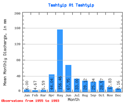
| Units: | m3/s |
| Statistic | Jan | Feb | Mar | Apr | May | Jun | Jul | Aug | Sep | Oct | Nov | Dec | Annual |
|---|---|---|---|---|---|---|---|---|---|---|---|---|---|
| Mean | 6.00 | 4.71 | 5.59 | 44.04 | 156.44 | 67.95 | 32.99 | 28.12 | 25.34 | 28.57 | 12.83 | 8.16 | 418.54 |
| Standard Deviation | 1.60 | 1.21 | 1.57 | 25.18 | 44.06 | 45.32 | 19.06 | 15.40 | 11.70 | 15.42 | 4.99 | 2.95 | 95.00 |
| Min | 3.62 | 2.96 | 3.00 | 10.50 | 90.42 | 22.71 | 13.51 | 8.05 | 9.35 | 10.21 | 6.71 | 3.62 | 256.78 |
| Max | 9.48 | 7.79 | 11.15 | 111.70 | 269.18 | 203.09 | 83.24 | 74.27 | 59.72 | 65.02 | 26.45 | 16.98 | 626.78 |
| Coefficient of Variation | 0.27 | 0.26 | 0.28 | 0.57 | 0.28 | 0.67 | 0.58 | 0.55 | 0.46 | 0.54 | 0.39 | 0.36 | 0.23 |
 Return to R-Arctic Net Home Page