|
|
|||||||||||||||||
| Point ID: 6574 | Downloads | Plots | Site Data | Code: 9226 |
|
|
|||||||||||||||||
| Download | |
|---|---|
| Site Descriptor Information | Site Time Series Data |
| Link to all available data | |
|
|
| View: | Statistics | Time Series |
| Units: | m3/s |
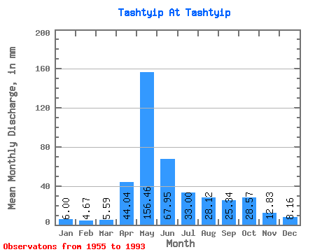
| Statistic | Jan | Feb | Mar | Apr | May | Jun | Jul | Aug | Sep | Oct | Nov | Dec | Annual |
|---|---|---|---|---|---|---|---|---|---|---|---|---|---|
| Mean | 6.00 | 4.71 | 5.59 | 44.04 | 156.44 | 67.95 | 32.99 | 28.12 | 25.34 | 28.57 | 12.83 | 8.16 | 418.54 |
| Standard Deviation | 1.60 | 1.21 | 1.57 | 25.18 | 44.06 | 45.32 | 19.06 | 15.40 | 11.70 | 15.42 | 4.99 | 2.95 | 95.00 |
| Min | 3.62 | 2.96 | 3.00 | 10.50 | 90.42 | 22.71 | 13.51 | 8.05 | 9.35 | 10.21 | 6.71 | 3.62 | 256.78 |
| Max | 9.48 | 7.79 | 11.15 | 111.70 | 269.18 | 203.09 | 83.24 | 74.27 | 59.72 | 65.02 | 26.45 | 16.98 | 626.78 |
| Coefficient of Variation | 0.27 | 0.26 | 0.28 | 0.57 | 0.28 | 0.67 | 0.58 | 0.55 | 0.46 | 0.54 | 0.39 | 0.36 | 0.23 |
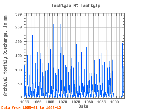
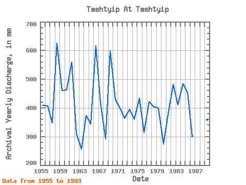
| Year | Jan | Feb | Mar | Apr | May | Jun | Jul | Aug | Sep | Oct | Nov | Dec | Annual | 1955 | 7.32 | 6.75 | 6.80 | 34.74 | 200.16 | 39.81 | 23.33 | 11.22 | 41.15 | 20.98 | 13.76 | 6.21 | 409.72 | 1956 | 4.13 | 4.50 | 5.25 | 29.53 | 155.99 | 70.14 | 22.64 | 19.46 | 37.28 | 41.83 | 12.32 | 7.05 | 408.06 | 1957 | 5.85 | 3.92 | 4.74 | 13.16 | 157.37 | 49.30 | 29.27 | 14.49 | 13.89 | 32.85 | 16.43 | 8.97 | 347.38 | 1958 | 7.44 | 5.23 | 7.21 | 18.17 | 227.77 | 203.09 | 74.54 | 31.89 | 18.04 | 18.22 | 10.66 | 7.16 | 626.78 | 1959 | 4.69 | 3.51 | 4.96 | 61.86 | 182.21 | 68.67 | 43.62 | 32.30 | 23.11 | 19.88 | 11.20 | 7.29 | 460.71 | 1960 | 5.66 | 4.87 | 5.09 | 40.48 | 168.41 | 100.87 | 57.42 | 28.85 | 23.38 | 15.46 | 8.39 | 6.94 | 463.60 | 1961 | 6.87 | 5.63 | 6.45 | 107.69 | 164.27 | 113.03 | 36.99 | 27.33 | 44.49 | 29.40 | 7.98 | 10.12 | 559.66 | 1962 | 9.14 | 7.79 | 11.15 | 57.99 | 126.45 | 29.93 | 17.95 | 10.35 | 9.35 | 17.81 | 7.88 | 6.60 | 310.95 | 1963 | 5.80 | 5.31 | 6.21 | 10.50 | 99.25 | 43.29 | 16.57 | 9.51 | 21.91 | 17.39 | 13.76 | 8.48 | 256.78 | 1964 | 5.94 | 3.14 | 4.50 | 18.57 | 186.36 | 68.81 | 22.91 | 24.30 | 12.99 | 11.55 | 9.17 | 8.30 | 373.65 | 1965 | 6.09 | 5.40 | 6.42 | 20.44 | 178.07 | 22.71 | 13.51 | 13.22 | 42.22 | 22.50 | 10.34 | 6.67 | 345.00 | 1966 | 6.16 | 5.14 | 6.25 | 50.91 | 269.18 | 181.71 | 33.68 | 31.75 | 13.05 | 10.21 | 6.71 | 4.69 | 617.06 | 1967 | 3.62 | 3.46 | 3.40 | 52.77 | 90.56 | 61.46 | 83.24 | 40.86 | 27.39 | 26.92 | 17.90 | 8.39 | 417.97 | 1968 | 3.69 | 3.11 | 4.36 | 50.24 | 105.05 | 29.39 | 21.53 | 30.92 | 17.90 | 12.73 | 8.44 | 7.32 | 293.15 | 1969 | 4.65 | 3.06 | 3.93 | 58.39 | 267.80 | 97.53 | 29.13 | 25.68 | 32.07 | 50.80 | 16.97 | 13.80 | 599.95 | 1970 | 6.05 | 4.55 | 5.36 | 24.18 | 157.37 | 82.17 | 31.89 | 34.65 | 25.52 | 41.27 | 10.80 | 7.87 | 429.01 | 1971 | 5.27 | 4.34 | 4.32 | 67.20 | 172.55 | 50.24 | 33.82 | 25.26 | 14.43 | 11.15 | 7.48 | 5.74 | 399.57 | 1972 | 5.15 | 4.48 | 4.26 | 52.37 | 94.83 | 37.95 | 59.91 | 35.34 | 21.64 | 24.16 | 15.37 | 11.54 | 365.00 | 1973 | 9.48 | 6.29 | 6.79 | 61.59 | 146.32 | 84.97 | 25.12 | 18.77 | 12.25 | 12.01 | 8.04 | 4.76 | 395.35 | 1974 | 4.80 | 3.75 | 4.76 | 58.92 | 110.98 | 29.39 | 13.80 | 8.05 | 38.08 | 63.36 | 13.63 | 11.78 | 359.75 | 1975 | 6.03 | 3.72 | 5.83 | 15.10 | 194.64 | 120.38 | 20.71 | 14.63 | 15.37 | 26.64 | 7.60 | 5.27 | 433.62 | 1976 | 4.24 | 3.32 | 3.91 | 29.93 | 130.03 | 25.79 | 13.78 | 44.73 | 18.70 | 28.71 | 8.32 | 4.83 | 313.63 | 1977 | 3.74 | 3.32 | 3.00 | 40.08 | 167.03 | 36.61 | 22.64 | 39.34 | 29.66 | 53.84 | 19.64 | 6.21 | 421.91 | 1978 | 5.59 | 4.79 | 6.53 | 74.42 | 144.94 | 65.60 | 24.71 | 23.74 | 21.24 | 20.15 | 10.18 | 3.62 | 404.30 | 1979 | 3.77 | 2.96 | 3.04 | 14.43 | 186.36 | 45.43 | 19.33 | 15.19 | 23.78 | 47.62 | 26.45 | 14.49 | 399.49 | 1980 | 6.18 | 4.75 | 5.84 | 31.00 | 91.94 | 40.35 | 30.92 | 24.30 | 12.49 | 14.63 | 9.98 | 4.14 | 275.08 | 1981 | 4.22 | 4.10 | 4.69 | 64.40 | 90.42 | 29.53 | 22.78 | 39.07 | 47.16 | 49.28 | 17.23 | 7.61 | 379.22 | 1982 | 5.69 | 4.57 | 4.68 | 111.70 | 137.07 | 46.23 | 23.19 | 48.18 | 17.23 | 49.97 | 23.78 | 11.72 | 482.25 | 1983 | 8.96 | 6.79 | 7.69 | 28.19 | 147.70 | 55.05 | 35.75 | 23.47 | 31.66 | 33.68 | 22.85 | 10.84 | 410.38 | 1984 | 8.99 | 5.19 | 6.90 | 34.87 | 140.80 | 56.65 | 78.55 | 74.27 | 22.58 | 37.82 | 13.31 | 8.06 | 483.89 | 1985 | 7.21 | 5.19 | 6.21 | 52.11 | 162.89 | 76.42 | 30.37 | 42.10 | 32.73 | 21.12 | 10.88 | 8.59 | 453.76 | 1986 | 7.19 | 5.87 | 6.53 | 28.86 | 129.48 | 42.09 | 15.05 | 18.36 | 20.31 | 12.46 | 9.03 | 7.37 | 301.01 | 1987 | 5.89 | 4.29 | 4.72 | 24.18 | 175.31 | 45.43 | 21.95 | 13.94 | 33.40 | 65.02 | 10.82 | 8.99 | 410.65 | 1988 | 8.09 | 6.17 | 6.57 | 86.18 | 134.04 | 45.03 | 73.02 | 72.75 | 22.58 | 19.05 | 11.90 | 7.04 | 489.59 | 1989 | 5.58 | 3.94 | 5.19 | 41.95 | 139.42 | 57.32 | 34.92 | 18.64 | 13.49 | 18.77 | 13.36 | 8.21 | 358.82 | 1993 | 6.90 | 6.30 | 7.63 | 18.44 | 198.78 | 193.73 | 29.27 | 25.40 | 59.72 | 29.13 | 19.37 | 16.98 | 610.78 |
|---|
 Return to R-Arctic Net Home Page