|
|
|||||||||||||||||
| Point ID: 6574 | Downloads | Plots | Site Data | Code: 9226 |
|
|
|||||||||||||||||
| Download | |
|---|---|
| Site Descriptor Information | Site Time Series Data |
| Link to all available data | |
| View: | Time Series | All |
| Units: | mm |
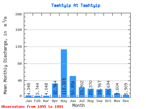
| Statistic | Jan | Feb | Mar | Apr | May | Jun | Jul | Aug | Sep | Oct | Nov | Dec | Annual |
|---|---|---|---|---|---|---|---|---|---|---|---|---|---|
| Mean | 4.35 | 3.74 | 4.05 | 32.96 | 113.33 | 50.86 | 23.90 | 20.37 | 18.97 | 20.69 | 9.60 | 5.91 | 25.73 |
| Standard Deviation | 1.16 | 0.96 | 1.14 | 18.85 | 31.92 | 33.92 | 13.81 | 11.15 | 8.76 | 11.17 | 3.74 | 2.14 | 5.84 |
| Min | 2.62 | 2.35 | 2.17 | 7.86 | 65.50 | 17.00 | 9.79 | 5.83 | 7.00 | 7.40 | 5.02 | 2.62 | 15.78 |
| Max | 6.87 | 6.19 | 8.08 | 83.60 | 195.00 | 152.00 | 60.30 | 53.80 | 44.70 | 47.10 | 19.80 | 12.30 | 38.53 |
| Coefficient of Variation | 0.27 | 0.26 | 0.28 | 0.57 | 0.28 | 0.67 | 0.58 | 0.55 | 0.46 | 0.54 | 0.39 | 0.36 | 0.23 |
 Return to R-Arctic Net Home Page