|
|
|||||||||||||||||
| Point ID: 6474 | Downloads | Plots | Site Data | Code: 8183 |
|
|
|||||||||||||||||
| Download | |
|---|---|
| Site Descriptor Information | Site Time Series Data |
| Link to all available data | |
| View: | Time Series | All |
| Units: | m3/s |
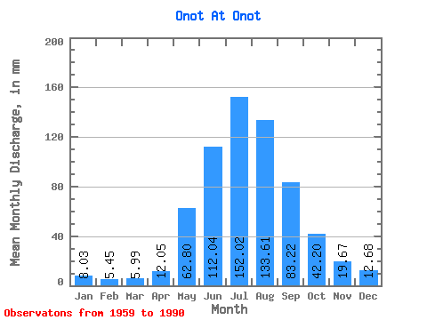
| Statistic | Jan | Feb | Mar | Apr | May | Jun | Jul | Aug | Sep | Oct | Nov | Dec | Annual |
|---|---|---|---|---|---|---|---|---|---|---|---|---|---|
| Mean | 8.03 | 5.50 | 5.99 | 12.05 | 62.79 | 112.04 | 152.00 | 133.59 | 83.22 | 42.20 | 19.67 | 12.68 | 646.03 |
| Standard Deviation | 2.12 | 1.44 | 1.52 | 4.60 | 18.03 | 35.48 | 50.20 | 44.33 | 23.00 | 7.93 | 4.46 | 3.02 | 102.48 |
| Min | 3.81 | 1.80 | 2.58 | 4.83 | 28.55 | 66.71 | 77.89 | 60.77 | 44.34 | 26.10 | 11.58 | 5.60 | 469.41 |
| Max | 12.49 | 7.94 | 8.95 | 23.42 | 107.39 | 197.36 | 271.88 | 259.64 | 140.78 | 60.36 | 28.95 | 17.81 | 832.36 |
| Coefficient of Variation | 0.26 | 0.26 | 0.25 | 0.38 | 0.29 | 0.32 | 0.33 | 0.33 | 0.28 | 0.19 | 0.23 | 0.24 | 0.16 |
 Return to R-Arctic Net Home Page