|
|
|||||||||||||||||
| Point ID: 6474 | Downloads | Plots | Site Data | Code: 8183 |
|
|
|||||||||||||||||
| Download | |
|---|---|
| Site Descriptor Information | Site Time Series Data |
| Link to all available data | |
|
|
| View: | Statistics | Time Series |
| Units: | m3/s |
| Statistic | Jan | Feb | Mar | Apr | May | Jun | Jul | Aug | Sep | Oct | Nov | Dec | Annual |
|---|---|---|---|---|---|---|---|---|---|---|---|---|---|
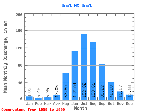
| Mean | 8.03 | 5.50 | 5.99 | 12.05 | 62.79 | 112.04 | 152.00 | 133.59 | 83.22 | 42.20 | 19.67 | 12.68 | 646.03 |
| Standard Deviation | 2.12 | 1.44 | 1.52 | 4.60 | 18.03 | 35.48 | 50.20 | 44.33 | 23.00 | 7.93 | 4.46 | 3.02 | 102.48 |
| Min | 3.81 | 1.80 | 2.58 | 4.83 | 28.55 | 66.71 | 77.89 | 60.77 | 44.34 | 26.10 | 11.58 | 5.60 | 469.41 |
| Max | 12.49 | 7.94 | 8.95 | 23.42 | 107.39 | 197.36 | 271.88 | 259.64 | 140.78 | 60.36 | 28.95 | 17.81 | 832.36 |
| Coefficient of Variation | 0.26 | 0.26 | 0.25 | 0.38 | 0.29 | 0.32 | 0.33 | 0.33 | 0.28 | 0.19 | 0.23 | 0.24 | 0.16 |
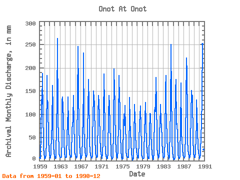
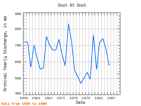
| Year | Jan | Feb | Mar | Apr | May | Jun | Jul | Aug | Sep | Oct | Nov | Dec | Annual | 1959 | 7.10 | 5.08 | 4.73 | 13.42 | 57.37 | 131.57 | 125.61 | 194.39 | 95.92 | 47.03 | 26.45 | 17.26 | 722.12 | 1960 | 6.48 | 4.89 | 6.51 | 13.81 | 41.33 | 182.89 | 128.87 | 133.36 | 122.76 | 42.28 | 25.26 | 13.36 | 720.57 | 1961 | 7.82 | 5.46 | 5.98 | 18.16 | 56.01 | 76.97 | 167.21 | 116.09 | 60.39 | 30.18 | 16.32 | 11.13 | 567.59 | 1962 | 6.96 | 4.94 | 5.97 | 11.91 | 78.57 | 124.86 | 271.88 | 93.12 | 52.63 | 29.77 | 13.68 | 11.20 | 699.94 | 1963 | 8.58 | 6.54 | 7.27 | 7.92 | 47.99 | 128.28 | 141.38 | 119.49 | 91.05 | 42.69 | 14.47 | 11.66 | 624.58 | 1964 | 9.69 | 7.00 | 7.26 | 8.36 | 56.96 | 78.42 | 112.42 | 141.38 | 77.89 | 34.39 | 13.42 | 11.23 | 554.88 | 1965 | 9.71 | 7.20 | 6.73 | 8.74 | 72.18 | 76.05 | 91.22 | 145.46 | 74.08 | 41.19 | 18.03 | 14.82 | 561.70 | 1966 | 10.26 | 7.61 | 6.63 | 7.91 | 54.78 | 122.63 | 254.21 | 157.69 | 71.18 | 37.11 | 18.68 | 11.37 | 754.34 | 1967 | 5.51 | 4.81 | 5.63 | 14.34 | 45.95 | 98.15 | 148.17 | 239.25 | 76.58 | 38.06 | 18.95 | 12.56 | 702.50 | 1968 | 9.71 | 7.26 | 7.92 | 14.61 | 81.29 | 101.31 | 180.80 | 125.47 | 73.42 | 40.51 | 20.52 | 12.93 | 671.17 | 1969 | 8.07 | 5.19 | 5.98 | 10.06 | 66.47 | 81.71 | 154.97 | 137.30 | 124.20 | 47.99 | 18.68 | 15.63 | 672.29 | 1970 | 12.49 | 7.94 | 7.53 | 10.45 | 99.37 | 140.78 | 144.09 | 129.14 | 96.58 | 52.61 | 23.29 | 15.90 | 736.51 | 1971 | 10.15 | 6.32 | 5.42 | 15.39 | 42.82 | 88.29 | 193.03 | 122.48 | 86.71 | 43.91 | 18.55 | 9.80 | 638.77 | 1972 | 7.30 | 5.04 | 5.22 | 15.79 | 28.55 | 93.02 | 145.46 | 122.75 | 75.79 | 42.55 | 26.84 | 12.37 | 577.64 | 1973 | 7.16 | 4.56 | 3.81 | 7.78 | 66.75 | 197.36 | 183.52 | 175.36 | 108.94 | 44.59 | 25.26 | 10.77 | 832.36 | 1974 | 8.28 | 6.32 | 6.53 | 23.42 | 85.37 | 182.89 | 135.94 | 123.30 | 79.21 | 55.46 | 23.55 | 5.60 | 733.34 | 1975 | 3.81 | 3.18 | 5.41 | 11.00 | 80.20 | 101.05 | 77.89 | 122.62 | 70.26 | 43.37 | 20.79 | 10.69 | 547.32 | 1976 | 8.69 | 7.29 | 7.46 | 6.89 | 44.18 | 86.58 | 140.02 | 87.41 | 63.02 | 38.47 | 15.66 | 8.10 | 510.87 | 1977 | 4.35 | 1.80 | 3.15 | 6.37 | 47.03 | 120.65 | 92.71 | 72.73 | 52.50 | 36.57 | 18.82 | 14.54 | 469.41 | 1978 | 9.23 | 5.39 | 6.44 | 12.25 | 40.78 | 82.36 | 98.56 | 122.07 | 69.21 | 36.43 | 13.81 | 8.43 | 502.22 | 1979 | 5.71 | 4.73 | 5.18 | 5.87 | 78.57 | 66.71 | 92.71 | 129.28 | 77.63 | 40.10 | 18.16 | 14.00 | 534.93 | 1980 | 10.44 | 5.81 | 4.96 | 4.83 | 63.08 | 101.44 | 85.51 | 104.40 | 59.34 | 33.30 | 14.34 | 8.90 | 493.88 | 1981 | 4.35 | 2.67 | 3.17 | 18.68 | 107.39 | 114.73 | 109.97 | 184.88 | 116.44 | 60.36 | 28.95 | 16.59 | 763.75 | 1982 | 7.94 | 5.81 | 8.95 | 20.39 | 72.18 | 72.76 | 125.20 | 85.37 | 77.23 | 46.49 | 17.76 | 16.99 | 553.78 | 1983 | 9.90 | 6.23 | 6.63 | 10.41 | 47.99 | 156.57 | 188.96 | 117.59 | 87.76 | 50.43 | 22.76 | 14.27 | 716.24 | 1984 | 10.07 | 6.22 | 4.34 | 9.58 | 71.78 | 100.92 | 258.28 | 138.66 | 79.08 | 41.73 | 18.68 | 9.31 | 742.61 | 1985 | 4.15 | 2.80 | 2.58 | 7.33 | 75.72 | 152.62 | 180.80 | 81.02 | 80.39 | 55.87 | 24.21 | 12.91 | 677.10 | 1986 | 7.78 | 5.15 | 5.15 | 10.45 | 76.67 | 153.94 | 172.64 | 60.77 | 44.34 | 26.10 | 11.58 | 9.96 | 581.72 | 1987 | 7.83 | 5.71 | 6.40 | 10.12 | 62.80 | 123.68 | 228.38 | 194.39 | 97.89 | 43.91 | 22.76 | 16.45 | 814.46 | 1988 | 9.42 | 5.56 | 8.27 | 16.58 | 43.09 | 97.63 | 156.33 | 137.30 | 140.78 | 45.00 | 19.47 | 14.82 | 691.28 | 1989 | 10.48 | 6.44 | 7.22 | 17.76 | 55.46 | 74.21 | 134.58 | 100.73 | 62.37 | 32.22 | 16.18 | 14.41 | 528.70 | 1990 | 7.45 | 4.98 | 7.16 | 15.00 | 60.63 | 74.21 | 142.74 | 259.64 | 117.63 | 49.62 | 23.68 | 17.81 | 774.54 |
|---|
 Return to R-Arctic Net Home Page