|
|
|||||||||||||||||
| Point ID: 6474 | Downloads | Plots | Site Data | Code: 8183 |
|
|
|||||||||||||||||
| Download | |
|---|---|
| Site Descriptor Information | Site Time Series Data |
| Link to all available data | |
| View: | Time Series | All |
| Units: | mm |
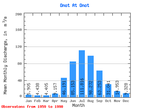
| Statistic | Jan | Feb | Mar | Apr | May | Jun | Jul | Aug | Sep | Oct | Nov | Dec | Annual |
|---|---|---|---|---|---|---|---|---|---|---|---|---|---|
| Mean | 5.91 | 4.44 | 4.41 | 9.16 | 46.19 | 85.15 | 111.82 | 98.27 | 63.25 | 31.04 | 14.95 | 9.33 | 40.33 |
| Standard Deviation | 1.56 | 1.16 | 1.11 | 3.50 | 13.27 | 26.97 | 36.93 | 32.61 | 17.48 | 5.83 | 3.39 | 2.22 | 6.40 |
| Min | 2.80 | 1.45 | 1.90 | 3.67 | 21.00 | 50.70 | 57.30 | 44.70 | 33.70 | 19.20 | 8.80 | 4.12 | 29.30 |
| Max | 9.19 | 6.41 | 6.58 | 17.80 | 79.00 | 150.00 | 200.00 | 191.00 | 107.00 | 44.40 | 22.00 | 13.10 | 51.96 |
| Coefficient of Variation | 0.26 | 0.26 | 0.25 | 0.38 | 0.29 | 0.32 | 0.33 | 0.33 | 0.28 | 0.19 | 0.23 | 0.24 | 0.16 |
 Return to R-Arctic Net Home Page