|
|
|||||||||||||||||
| Point ID: 6463 | Downloads | Plots | Site Data | Other Close Sites | Code: 8109 |
|
|
|||||||||||||||||
| Download | |
|---|---|
| Site Descriptor Information | Site Time Series Data |
| Link to all available data | |
| View: | Time Series | All |
| Units: | m3/s |
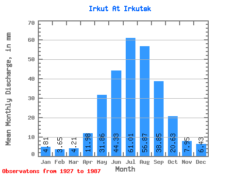
| Statistic | Jan | Feb | Mar | Apr | May | Jun | Jul | Aug | Sep | Oct | Nov | Dec | Annual |
|---|---|---|---|---|---|---|---|---|---|---|---|---|---|
| Mean | 4.81 | 3.68 | 4.21 | 11.98 | 31.86 | 44.33 | 61.00 | 56.86 | 38.85 | 20.62 | 7.95 | 6.43 | 291.35 |
| Standard Deviation | 1.19 | 0.92 | 1.00 | 3.00 | 9.29 | 17.45 | 24.07 | 16.64 | 11.81 | 4.10 | 1.88 | 1.30 | 49.37 |
| Min | 1.70 | 1.44 | 1.36 | 5.81 | 16.78 | 23.50 | 28.57 | 27.67 | 23.85 | 14.39 | 4.22 | 3.20 | 198.90 |
| Max | 7.12 | 5.29 | 6.23 | 18.32 | 58.56 | 105.93 | 144.61 | 105.69 | 80.53 | 33.39 | 13.86 | 9.46 | 435.21 |
| Coefficient of Variation | 0.25 | 0.25 | 0.24 | 0.25 | 0.29 | 0.39 | 0.40 | 0.29 | 0.30 | 0.20 | 0.24 | 0.20 | 0.17 |
| Other Close Sites | ||||||
|---|---|---|---|---|---|---|
| PointID | Latitude | Longitude | Drainage Area | Source | Name | |
| 6453 | "Angara At Irkutskaya GES" | 52.23 | 1018710 | SHI | ||
| 6454 | "Angara At Ostrov Yunost'" | 52.27 | 1019064 | SHI | 1717.00 | |
 Return to R-Arctic Net Home Page