|
|
|||||||||||||||||
| Point ID: 6453 | Downloads | Plots | Site Data | Other Close Sites | Code: 8013 |
|
|
|||||||||||||||||
| Download | |
|---|---|
| Site Descriptor Information | Site Time Series Data |
| Link to all available data | |
| View: | Time Series | All |
| Units: | m3/s |
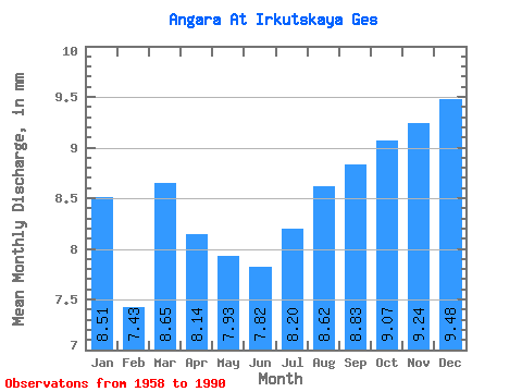
| Statistic | Jan | Feb | Mar | Apr | May | Jun | Jul | Aug | Sep | Oct | Nov | Dec | Annual |
|---|---|---|---|---|---|---|---|---|---|---|---|---|---|
| Mean | 8.51 | 7.49 | 8.64 | 8.14 | 7.93 | 7.82 | 8.19 | 8.62 | 8.82 | 9.07 | 9.24 | 9.48 | 102.63 |
| Standard Deviation | 1.76 | 1.42 | 1.77 | 1.89 | 1.47 | 1.08 | 1.83 | 2.57 | 2.66 | 2.36 | 2.21 | 2.15 | 15.21 |
| Min | 5.79 | 5.11 | 5.33 | 4.98 | 5.28 | 5.93 | 6.17 | 6.17 | 5.97 | 6.17 | 5.75 | 5.89 | 71.46 |
| Max | 11.92 | 11.41 | 12.67 | 11.85 | 10.75 | 9.82 | 15.28 | 16.17 | 16.29 | 14.02 | 12.71 | 12.85 | 135.86 |
| Coefficient of Variation | 0.21 | 0.19 | 0.20 | 0.23 | 0.18 | 0.14 | 0.22 | 0.30 | 0.30 | 0.26 | 0.24 | 0.23 | 0.15 |
| Other Close Sites | ||||||
|---|---|---|---|---|---|---|
| PointID | Latitude | Longitude | Drainage Area | Source | Name | |
| 6454 | "Angara At Ostrov Yunost'" | 52.27 | 1019064 | SHI | 1717.00 | |
| 6463 | "Irkut At Irkutsk" | 52.28 | 1016017 | SHI | 2.00 | |
 Return to R-Arctic Net Home Page