|
|
|||||||||||||||||
| Point ID: 6463 | Downloads | Plots | Site Data | Other Close Sites | Code: 8109 |
|
|
|||||||||||||||||
| Download | |
|---|---|
| Site Descriptor Information | Site Time Series Data |
| Link to all available data | |
| View: | Time Series | All |
| Units: | mm |
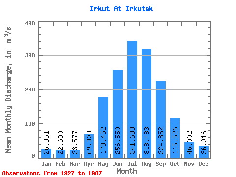
| Statistic | Jan | Feb | Mar | Apr | May | Jun | Jul | Aug | Sep | Oct | Nov | Dec | Annual |
|---|---|---|---|---|---|---|---|---|---|---|---|---|---|
| Mean | 26.95 | 22.63 | 23.58 | 69.30 | 178.45 | 256.55 | 341.68 | 318.48 | 224.85 | 115.53 | 46.00 | 36.02 | 138.47 |
| Standard Deviation | 6.67 | 5.64 | 5.62 | 17.37 | 52.03 | 100.97 | 134.79 | 93.20 | 68.37 | 22.98 | 10.89 | 7.26 | 23.46 |
| Min | 9.54 | 8.88 | 7.62 | 33.60 | 94.00 | 136.00 | 160.00 | 155.00 | 138.00 | 80.60 | 24.40 | 17.90 | 94.53 |
| Max | 39.90 | 32.50 | 34.90 | 106.00 | 328.00 | 613.00 | 810.00 | 592.00 | 466.00 | 187.00 | 80.20 | 53.00 | 206.85 |
| Coefficient of Variation | 0.25 | 0.25 | 0.24 | 0.25 | 0.29 | 0.39 | 0.40 | 0.29 | 0.30 | 0.20 | 0.24 | 0.20 | 0.17 |
| Other Close Sites | ||||||
|---|---|---|---|---|---|---|
| PointID | Latitude | Longitude | Drainage Area | Source | Name | |
| 6453 | "Angara At Irkutskaya GES" | 52.23 | 1018710 | SHI | ||
| 6454 | "Angara At Ostrov Yunost'" | 52.27 | 1019064 | SHI | 1717.00 | |
 Return to R-Arctic Net Home Page