|
|
|||||||||||||||||
| Point ID: 6167 | Downloads | Plots | Site Data | Code: 3089 |
|
|
|||||||||||||||||
| Download | |
|---|---|
| Site Descriptor Information | Site Time Series Data |
| Link to all available data | |
| View: | Time Series | All |
| Units: | m3/s |
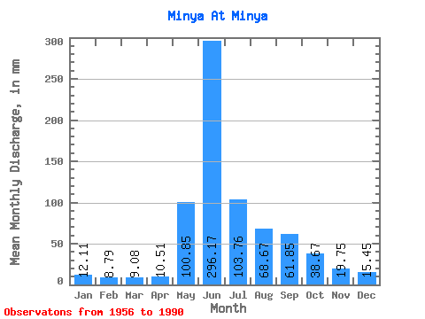
| Statistic | Jan | Feb | Mar | Apr | May | Jun | Jul | Aug | Sep | Oct | Nov | Dec | Annual |
|---|---|---|---|---|---|---|---|---|---|---|---|---|---|
| Mean | 12.11 | 8.86 | 9.08 | 10.51 | 100.83 | 296.17 | 103.74 | 68.66 | 61.85 | 38.66 | 19.75 | 15.45 | 743.66 |
| Standard Deviation | 1.96 | 1.78 | 1.92 | 3.20 | 39.95 | 87.38 | 39.98 | 24.07 | 21.55 | 13.14 | 6.13 | 2.83 | 107.88 |
| Min | 8.20 | 4.73 | 6.25 | 7.29 | 38.94 | 118.80 | 48.04 | 32.53 | 25.11 | 14.00 | 10.53 | 7.48 | 580.08 |
| Max | 16.01 | 13.01 | 13.89 | 20.52 | 190.25 | 459.00 | 228.19 | 132.78 | 129.60 | 77.55 | 32.94 | 22.20 | 998.96 |
| Coefficient of Variation | 0.16 | 0.20 | 0.21 | 0.30 | 0.40 | 0.29 | 0.39 | 0.35 | 0.35 | 0.34 | 0.31 | 0.18 | 0.14 |
 Return to R-Arctic Net Home Page