|
|
|||||||||||||||||
| Point ID: 6167 | Downloads | Plots | Site Data | Code: 3089 |
|
|
|||||||||||||||||
| Download | |
|---|---|
| Site Descriptor Information | Site Time Series Data |
| Link to all available data | |
| View: | Time Series | All |
| Units: | mm |
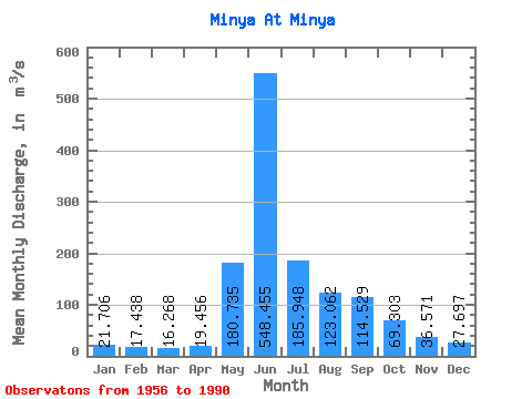
| Statistic | Jan | Feb | Mar | Apr | May | Jun | Jul | Aug | Sep | Oct | Nov | Dec | Annual |
|---|---|---|---|---|---|---|---|---|---|---|---|---|---|
| Mean | 21.71 | 17.44 | 16.27 | 19.46 | 180.74 | 548.46 | 185.95 | 123.06 | 114.53 | 69.30 | 36.57 | 27.70 | 113.11 |
| Standard Deviation | 3.52 | 3.51 | 3.44 | 5.93 | 71.61 | 161.81 | 71.65 | 43.13 | 39.91 | 23.55 | 11.35 | 5.08 | 16.41 |
| Min | 14.70 | 9.30 | 11.20 | 13.50 | 69.80 | 220.00 | 86.10 | 58.30 | 46.50 | 25.10 | 19.50 | 13.40 | 88.22 |
| Max | 28.70 | 25.60 | 24.90 | 38.00 | 341.00 | 850.00 | 409.00 | 238.00 | 240.00 | 139.00 | 61.00 | 39.80 | 151.93 |
| Coefficient of Variation | 0.16 | 0.20 | 0.21 | 0.30 | 0.40 | 0.29 | 0.39 | 0.35 | 0.35 | 0.34 | 0.31 | 0.18 | 0.14 |
 Return to R-Arctic Net Home Page