|
|
|||||||||||||||||
| Point ID: 6167 | Downloads | Plots | Site Data | Code: 3089 |
|
|
|||||||||||||||||
| Download | |
|---|---|
| Site Descriptor Information | Site Time Series Data |
| Link to all available data | |
|
|
| View: | Statistics | Time Series |
| Units: | m3/s |
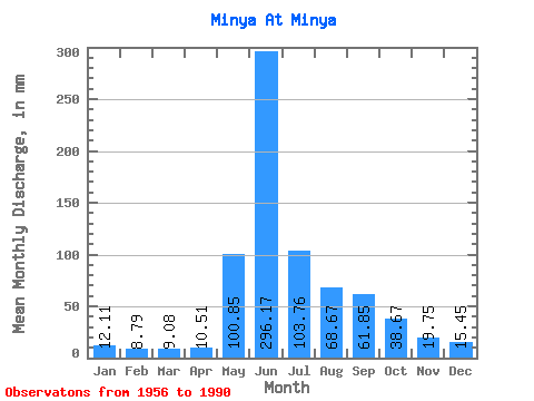
| Statistic | Jan | Feb | Mar | Apr | May | Jun | Jul | Aug | Sep | Oct | Nov | Dec | Annual |
|---|---|---|---|---|---|---|---|---|---|---|---|---|---|
| Mean | 12.11 | 8.86 | 9.08 | 10.51 | 100.83 | 296.17 | 103.74 | 68.66 | 61.85 | 38.66 | 19.75 | 15.45 | 743.66 |
| Standard Deviation | 1.96 | 1.78 | 1.92 | 3.20 | 39.95 | 87.38 | 39.98 | 24.07 | 21.55 | 13.14 | 6.13 | 2.83 | 107.88 |
| Min | 8.20 | 4.73 | 6.25 | 7.29 | 38.94 | 118.80 | 48.04 | 32.53 | 25.11 | 14.00 | 10.53 | 7.48 | 580.08 |
| Max | 16.01 | 13.01 | 13.89 | 20.52 | 190.25 | 459.00 | 228.19 | 132.78 | 129.60 | 77.55 | 32.94 | 22.20 | 998.96 |
| Coefficient of Variation | 0.16 | 0.20 | 0.21 | 0.30 | 0.40 | 0.29 | 0.39 | 0.35 | 0.35 | 0.34 | 0.31 | 0.18 | 0.14 |
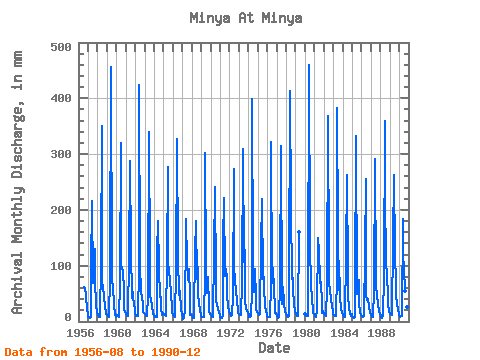
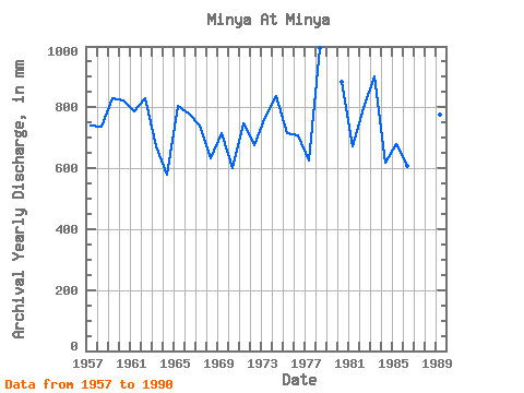
| Year | Jan | Feb | Mar | Apr | May | Jun | Jul | Aug | Sep | Oct | Nov | Dec | Annual | 1956 | 63.60 | 59.94 | 48.48 | 20.09 | 13.45 | 1957 | 8.54 | 6.86 | 6.81 | 7.40 | 99.31 | 216.00 | 70.86 | 74.76 | 129.60 | 77.55 | 27.00 | 17.35 | 741.77 | 1958 | 12.50 | 9.25 | 8.87 | 8.53 | 109.91 | 350.46 | 67.51 | 68.07 | 41.90 | 28.62 | 15.23 | 14.67 | 736.78 | 1959 | 12.33 | 9.25 | 9.15 | 8.37 | 82.57 | 455.22 | 78.11 | 60.26 | 61.56 | 29.90 | 11.23 | 7.48 | 829.00 | 1960 | 11.49 | 9.05 | 9.48 | 8.59 | 73.64 | 319.68 | 103.77 | 97.08 | 90.72 | 58.02 | 22.84 | 17.07 | 821.99 | 1961 | 13.95 | 10.06 | 10.32 | 14.36 | 112.14 | 287.28 | 131.67 | 43.07 | 65.88 | 43.80 | 32.94 | 22.20 | 787.58 | 1962 | 14.06 | 9.51 | 9.60 | 9.67 | 99.87 | 423.36 | 100.42 | 56.35 | 40.61 | 33.48 | 17.06 | 15.90 | 831.90 | 1963 | 14.12 | 9.86 | 10.49 | 9.72 | 46.98 | 339.66 | 102.10 | 44.80 | 39.91 | 29.07 | 12.74 | 12.50 | 673.94 | 1964 | 12.89 | 8.39 | 8.37 | 8.42 | 126.65 | 180.36 | 97.08 | 45.36 | 43.96 | 22.99 | 11.61 | 15.68 | 580.08 | 1965 | 14.73 | 11.74 | 12.89 | 10.53 | 111.58 | 277.02 | 111.03 | 93.73 | 71.82 | 54.45 | 21.55 | 15.96 | 806.10 | 1966 | 12.39 | 9.66 | 8.70 | 8.80 | 93.73 | 327.78 | 121.07 | 48.87 | 59.94 | 50.32 | 24.62 | 12.83 | 779.41 | 1967 | 9.09 | 4.73 | 7.25 | 20.52 | 167.38 | 183.60 | 109.91 | 77.55 | 94.50 | 44.97 | 11.72 | 12.50 | 740.95 | 1968 | 9.60 | 5.74 | 6.25 | 13.55 | 128.32 | 179.28 | 79.22 | 100.98 | 45.85 | 36.60 | 17.06 | 13.00 | 632.95 | 1969 | 9.54 | 7.22 | 7.53 | 7.94 | 87.03 | 301.86 | 101.54 | 51.89 | 79.38 | 29.18 | 16.96 | 14.51 | 715.69 | 1970 | 11.83 | 9.56 | 7.87 | 8.64 | 126.65 | 240.30 | 74.76 | 38.72 | 31.48 | 23.32 | 17.01 | 11.72 | 601.67 | 1971 | 8.20 | 6.46 | 6.64 | 9.77 | 147.29 | 221.94 | 83.69 | 96.52 | 78.30 | 48.20 | 27.16 | 17.02 | 749.33 | 1972 | 13.05 | 10.78 | 9.88 | 11.39 | 45.47 | 273.78 | 107.12 | 69.18 | 60.48 | 31.80 | 25.54 | 16.46 | 675.97 | 1973 | 13.22 | 10.98 | 11.55 | 11.56 | 72.53 | 309.42 | 109.35 | 132.78 | 39.20 | 22.88 | 18.90 | 15.90 | 767.90 | 1974 | 11.33 | 7.98 | 8.31 | 10.31 | 53.84 | 399.60 | 113.26 | 55.18 | 94.50 | 41.73 | 22.52 | 17.41 | 838.91 | 1975 | 16.01 | 10.83 | 13.89 | 15.50 | 137.25 | 219.78 | 78.11 | 102.66 | 60.48 | 30.96 | 16.25 | 14.34 | 714.43 | 1976 | 10.60 | 7.73 | 7.53 | 7.61 | 69.18 | 321.84 | 71.97 | 99.31 | 57.24 | 25.72 | 14.36 | 15.90 | 710.10 | 1977 | 10.49 | 6.10 | 6.30 | 7.99 | 68.62 | 314.82 | 48.87 | 32.53 | 61.56 | 33.53 | 17.12 | 15.01 | 625.45 | 1978 | 13.39 | 9.15 | 9.09 | 10.64 | 63.60 | 412.56 | 208.10 | 78.67 | 77.22 | 59.14 | 31.97 | 19.92 | 993.87 | 1979 | 14.79 | 10.57 | 10.66 | 9.83 | 166.26 | 1980 | 13.11 | 9.56 | 9.71 | 9.34 | 38.94 | 459.00 | 138.36 | 70.30 | 59.40 | 46.75 | 14.74 | 13.84 | 885.82 | 1981 | 12.55 | 9.05 | 8.87 | 20.47 | 155.10 | 124.74 | 136.69 | 71.41 | 70.74 | 33.03 | 14.74 | 18.58 | 672.24 | 1982 | 14.34 | 10.22 | 10.04 | 12.47 | 60.26 | 368.28 | 107.68 | 68.62 | 56.16 | 42.01 | 25.49 | 19.02 | 796.40 | 1983 | 13.39 | 10.17 | 10.38 | 9.13 | 88.15 | 383.40 | 165.70 | 58.58 | 77.76 | 44.47 | 23.76 | 16.18 | 901.98 | 1984 | 12.61 | 8.74 | 8.76 | 8.32 | 125.53 | 262.98 | 82.01 | 45.53 | 25.11 | 14.00 | 10.53 | 13.61 | 617.50 | 1985 | 10.21 | 7.22 | 7.03 | 7.29 | 58.58 | 332.64 | 51.10 | 66.39 | 73.98 | 33.53 | 17.44 | 12.83 | 680.84 | 1986 | 10.43 | 8.13 | 7.98 | 9.23 | 128.88 | 254.88 | 48.04 | 39.72 | 39.58 | 26.78 | 15.55 | 17.35 | 606.87 | 1987 | 11.44 | 8.44 | 8.09 | 8.75 | 58.02 | 291.06 | 73.09 | 42.01 | 46.17 | 32.92 | 17.93 | 13.05 | 612.68 | 1988 | 9.82 | 7.07 | 6.97 | 10.21 | 84.25 | 359.10 | 228.19 | 113.26 | 78.30 | 51.89 | 31.21 | 20.36 | 998.96 | 1989 | 14.39 | 13.01 | 13.33 | 12.47 | 150.64 | 262.98 | 123.30 | 70.86 | 45.85 | 33.08 | 20.79 | 15.57 | 774.75 | 1990 | 11.33 | 8.34 | 9.99 | 9.88 | 190.25 | 118.80 | 99.87 | 55.79 | 43.69 | 51.44 | 25.76 | 16.23 | 637.12 |
|---|
 Return to R-Arctic Net Home Page