|
|
|||||||||||||||||
| Point ID: 6166 | Downloads | Plots | Site Data | Code: 3088 |
|
|
|||||||||||||||||
| Download | |
|---|---|
| Site Descriptor Information | Site Time Series Data |
| Link to all available data | |
| View: | Time Series | All |
| Units: | m3/s |
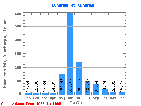
| Statistic | Jan | Feb | Mar | Apr | May | Jun | Jul | Aug | Sep | Oct | Nov | Dec | Annual |
|---|---|---|---|---|---|---|---|---|---|---|---|---|---|
| Mean | 13.54 | 11.46 | 12.34 | 14.10 | 150.40 | 596.04 | 240.14 | 100.07 | 80.54 | 44.73 | 22.32 | 16.26 | 1313.67 |
| Standard Deviation | 6.34 | 6.12 | 6.35 | 6.17 | 125.62 | 136.74 | 116.29 | 36.97 | 43.56 | 11.05 | 3.30 | 4.29 | 201.62 |
| Min | 6.09 | 4.48 | 5.28 | 5.94 | 21.45 | 360.82 | 94.85 | 50.72 | 22.48 | 28.15 | 17.48 | 9.99 | 1090.60 |
| Max | 26.43 | 23.84 | 25.87 | 25.87 | 389.53 | 839.46 | 416.92 | 150.13 | 172.80 | 65.94 | 27.44 | 24.55 | 1598.47 |
| Coefficient of Variation | 0.47 | 0.53 | 0.52 | 0.44 | 0.83 | 0.23 | 0.48 | 0.37 | 0.54 | 0.25 | 0.15 | 0.26 | 0.15 |
 Return to R-Arctic Net Home Page