|
|
|||||||||||||||||
| Point ID: 6166 | Downloads | Plots | Site Data | Code: 3088 |
|
|
|||||||||||||||||
| Download | |
|---|---|
| Site Descriptor Information | Site Time Series Data |
| Link to all available data | |
| View: | Time Series | All |
| Units: | mm |
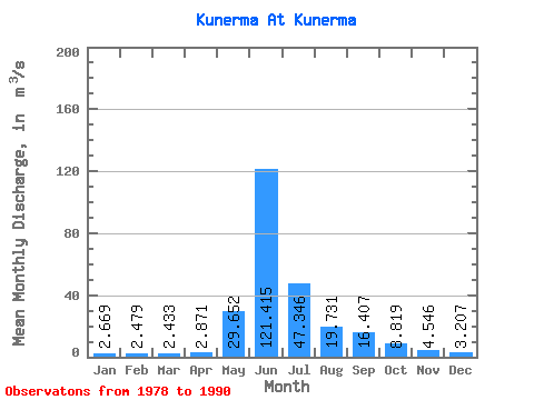
| Statistic | Jan | Feb | Mar | Apr | May | Jun | Jul | Aug | Sep | Oct | Nov | Dec | Annual |
|---|---|---|---|---|---|---|---|---|---|---|---|---|---|
| Mean | 2.67 | 2.48 | 2.43 | 2.87 | 29.65 | 121.42 | 47.35 | 19.73 | 16.41 | 8.82 | 4.55 | 3.21 | 21.98 |
| Standard Deviation | 1.25 | 1.32 | 1.25 | 1.26 | 24.77 | 27.85 | 22.93 | 7.29 | 8.87 | 2.18 | 0.67 | 0.85 | 3.37 |
| Min | 1.20 | 0.97 | 1.04 | 1.21 | 4.23 | 73.50 | 18.70 | 10.00 | 4.58 | 5.55 | 3.56 | 1.97 | 18.25 |
| Max | 5.21 | 5.16 | 5.10 | 5.27 | 76.80 | 171.00 | 82.20 | 29.60 | 35.20 | 13.00 | 5.59 | 4.84 | 26.74 |
| Coefficient of Variation | 0.47 | 0.53 | 0.52 | 0.44 | 0.83 | 0.23 | 0.48 | 0.37 | 0.54 | 0.25 | 0.15 | 0.26 | 0.15 |
 Return to R-Arctic Net Home Page