|
|
|||||||||||||||||
| Point ID: 6166 | Downloads | Plots | Site Data | Code: 3088 |
|
|
|||||||||||||||||
| Download | |
|---|---|
| Site Descriptor Information | Site Time Series Data |
| Link to all available data | |
|
|
| View: | Statistics | Time Series |
| Units: | m3/s |
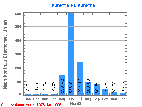
| Statistic | Jan | Feb | Mar | Apr | May | Jun | Jul | Aug | Sep | Oct | Nov | Dec | Annual |
|---|---|---|---|---|---|---|---|---|---|---|---|---|---|
| Mean | 13.54 | 11.46 | 12.34 | 14.10 | 150.40 | 596.04 | 240.14 | 100.07 | 80.54 | 44.73 | 22.32 | 16.26 | 1313.67 |
| Standard Deviation | 6.34 | 6.12 | 6.35 | 6.17 | 125.62 | 136.74 | 116.29 | 36.97 | 43.56 | 11.05 | 3.30 | 4.29 | 201.62 |
| Min | 6.09 | 4.48 | 5.28 | 5.94 | 21.45 | 360.82 | 94.85 | 50.72 | 22.48 | 28.15 | 17.48 | 9.99 | 1090.60 |
| Max | 26.43 | 23.84 | 25.87 | 25.87 | 389.53 | 839.46 | 416.92 | 150.13 | 172.80 | 65.94 | 27.44 | 24.55 | 1598.47 |
| Coefficient of Variation | 0.47 | 0.53 | 0.52 | 0.44 | 0.83 | 0.23 | 0.48 | 0.37 | 0.54 | 0.25 | 0.15 | 0.26 | 0.15 |
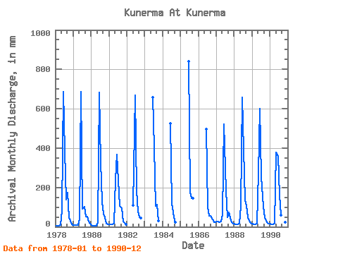
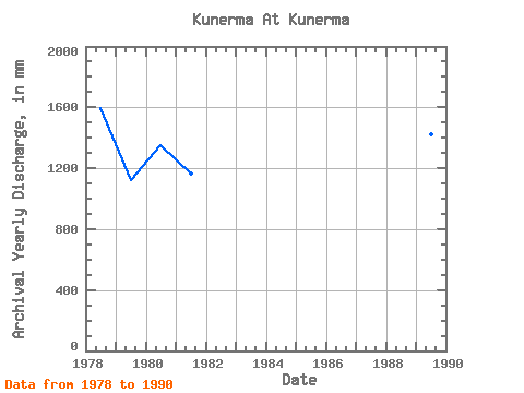
| Year | Jan | Feb | Mar | Apr | May | Jun | Jul | Aug | Sep | Oct | Nov | Dec | Annual | 1978 | 6.09 | 4.48 | 6.54 | 9.82 | 87.75 | 687.27 | 397.13 | 144.04 | 172.80 | 51.23 | 20.52 | 9.99 | 1598.47 | 1979 | 8.47 | 8.36 | 8.93 | 8.49 | 41.79 | 687.27 | 94.85 | 107.02 | 51.05 | 52.75 | 27.44 | 16.89 | 1119.39 | 1980 | 8.82 | 5.08 | 5.28 | 5.94 | 21.45 | 682.36 | 342.36 | 132.89 | 66.76 | 49.86 | 17.48 | 13.19 | 1352.91 | 1981 | 12.27 | 10.40 | 11.67 | 16.15 | 244.98 | 367.69 | 243.96 | 108.54 | 94.75 | 28.15 | 18.26 | 11.77 | 1164.82 | 1982 | 112.60 | 667.64 | 191.21 | 79.63 | 50.07 | 46.87 | 1983 | 657.82 | 416.92 | 110.57 | 113.89 | 33.12 | 1984 | 525.27 | 123.76 | 50.72 | 22.48 | 1985 | 839.46 | 182.08 | 150.13 | 145.31 | 1986 | 495.82 | 100.93 | 56.30 | 55.47 | 38.14 | 22.43 | 24.55 | 1987 | 26.43 | 23.84 | 25.87 | 25.87 | 63.40 | 520.36 | 189.69 | 51.23 | 73.14 | 45.70 | 24.35 | 16.94 | 1090.60 | 1988 | 15.22 | 13.03 | 13.54 | 15.07 | 110.57 | 657.82 | 406.77 | 143.54 | 105.06 | 48.44 | 24.94 | 16.89 | 1570.13 | 1989 | 15.57 | 13.22 | 13.34 | 15.02 | 281.49 | 598.91 | 264.25 | 106.00 | 45.70 | 31.85 | 20.91 | 17.14 | 1421.35 | 1990 | 15.42 | 13.22 | 13.54 | 16.40 | 389.53 | 360.82 | 167.88 | 60.36 | 50.56 | 65.94 | 24.50 | 19.02 | 1191.72 |
|---|
 Return to R-Arctic Net Home Page