|
|
|||||||||||||||||
| Point ID: 6165 | Downloads | Plots | Site Data | Other Close Sites | Code: 3087 |
|
|
|||||||||||||||||
| Download | |
|---|---|
| Site Descriptor Information | Site Time Series Data |
| Link to all available data | |
| View: | Time Series | All |
| Units: | m3/s |
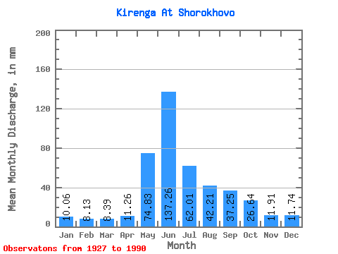
| Statistic | Jan | Feb | Mar | Apr | May | Jun | Jul | Aug | Sep | Oct | Nov | Dec | Annual |
|---|---|---|---|---|---|---|---|---|---|---|---|---|---|
| Mean | 10.06 | 8.20 | 8.39 | 11.26 | 74.82 | 137.26 | 62.00 | 42.20 | 37.25 | 26.64 | 11.91 | 11.74 | 441.04 |
| Standard Deviation | 1.92 | 1.38 | 1.25 | 6.08 | 18.36 | 35.75 | 21.80 | 13.21 | 11.95 | 7.96 | 3.60 | 2.47 | 64.41 |
| Min | 6.28 | 4.76 | 5.40 | 6.63 | 41.41 | 64.66 | 27.24 | 23.04 | 18.67 | 9.45 | 3.92 | 6.51 | 313.85 |
| Max | 15.09 | 12.38 | 12.27 | 41.03 | 113.45 | 212.93 | 138.22 | 77.75 | 73.02 | 58.74 | 19.62 | 22.34 | 572.72 |
| Coefficient of Variation | 0.19 | 0.17 | 0.15 | 0.54 | 0.24 | 0.26 | 0.35 | 0.31 | 0.32 | 0.30 | 0.30 | 0.21 | 0.15 |
| Other Close Sites | ||||||
|---|---|---|---|---|---|---|
| PointID | Latitude | Longitude | Drainage Area | Source | Name | |
| 6144 | "Lena At Zmeinovo" | 57.78 | 1111388 | SHI | 3139.00 | |
 Return to R-Arctic Net Home Page