|
|
|||||||||||||||||
| Point ID: 6144 | Downloads | Plots | Site Data | Other Close Sites | Code: 3021 |
|
|
|||||||||||||||||
| Download | |
|---|---|
| Site Descriptor Information | Site Time Series Data |
| Link to all available data | |
| View: | Time Series | All |
| Units: | m3/s |
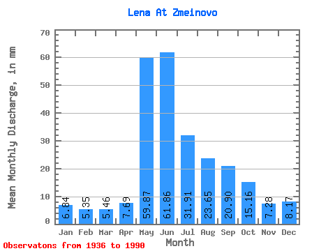
| Statistic | Jan | Feb | Mar | Apr | May | Jun | Jul | Aug | Sep | Oct | Nov | Dec | Annual |
|---|---|---|---|---|---|---|---|---|---|---|---|---|---|
| Mean | 6.83 | 5.40 | 5.46 | 7.69 | 59.87 | 61.86 | 31.90 | 23.64 | 20.90 | 15.16 | 7.28 | 8.17 | 253.31 |
| Standard Deviation | 1.24 | 0.94 | 0.94 | 5.00 | 12.16 | 17.33 | 12.16 | 8.64 | 7.14 | 4.83 | 1.77 | 1.72 | 41.71 |
| Min | 4.63 | 3.85 | 3.86 | 3.81 | 34.24 | 29.99 | 13.96 | 9.66 | 9.20 | 7.34 | 4.13 | 5.28 | 169.88 |
| Max | 9.37 | 7.67 | 7.52 | 33.88 | 85.70 | 96.46 | 71.54 | 48.40 | 44.80 | 30.41 | 11.11 | 12.55 | 344.64 |
| Coefficient of Variation | 0.18 | 0.17 | 0.17 | 0.65 | 0.20 | 0.28 | 0.38 | 0.37 | 0.34 | 0.32 | 0.24 | 0.21 | 0.17 |
| Other Close Sites | ||||||
|---|---|---|---|---|---|---|
| PointID | Latitude | Longitude | Drainage Area | Source | Name | |
| 6165 | "Kirenga At Shorokhovo" | 57.63 | 1104648 | SHI | 18.00 | |
 Return to R-Arctic Net Home Page