|
|
|||||||||||||||||
| Point ID: 6144 | Downloads | Plots | Site Data | Other Close Sites | Code: 3021 |
|
|
|||||||||||||||||
| Download | |
|---|---|
| Site Descriptor Information | Site Time Series Data |
| Link to all available data | |
| View: | Time Series | All |
| Units: | mm |
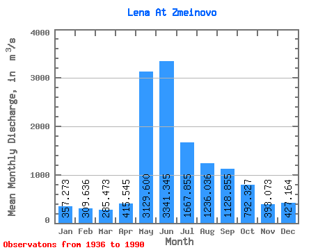
| Statistic | Jan | Feb | Mar | Apr | May | Jun | Jul | Aug | Sep | Oct | Nov | Dec | Annual |
|---|---|---|---|---|---|---|---|---|---|---|---|---|---|
| Mean | 357.27 | 309.64 | 285.47 | 415.55 | 3129.60 | 3341.34 | 1667.86 | 1236.04 | 1128.86 | 792.33 | 393.07 | 427.16 | 1123.68 |
| Standard Deviation | 64.81 | 53.88 | 49.31 | 270.31 | 635.86 | 935.86 | 635.55 | 451.90 | 385.60 | 252.63 | 95.38 | 90.06 | 185.04 |
| Min | 242.00 | 221.00 | 202.00 | 206.00 | 1790.00 | 1620.00 | 730.00 | 505.00 | 497.00 | 384.00 | 223.00 | 276.00 | 753.58 |
| Max | 490.00 | 440.00 | 393.00 | 1830.00 | 4480.00 | 5210.00 | 3740.00 | 2530.00 | 2420.00 | 1590.00 | 600.00 | 656.00 | 1528.83 |
| Coefficient of Variation | 0.18 | 0.17 | 0.17 | 0.65 | 0.20 | 0.28 | 0.38 | 0.37 | 0.34 | 0.32 | 0.24 | 0.21 | 0.17 |
| Other Close Sites | ||||||
|---|---|---|---|---|---|---|
| PointID | Latitude | Longitude | Drainage Area | Source | Name | |
| 6165 | "Kirenga At Shorokhovo" | 57.63 | 1104648 | SHI | 18.00 | |
 Return to R-Arctic Net Home Page