|
|
|||||||||||||||||
| Point ID: 6165 | Downloads | Plots | Site Data | Other Close Sites | Code: 3087 |
|
|
|||||||||||||||||
| Download | |
|---|---|
| Site Descriptor Information | Site Time Series Data |
| Link to all available data | |
| View: | Time Series | All |
| Units: | mm |
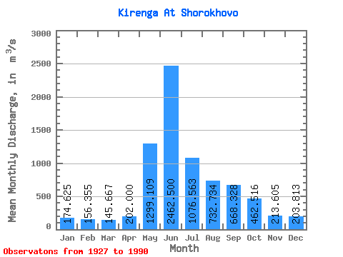
| Statistic | Jan | Feb | Mar | Apr | May | Jun | Jul | Aug | Sep | Oct | Nov | Dec | Annual |
|---|---|---|---|---|---|---|---|---|---|---|---|---|---|
| Mean | 174.62 | 156.35 | 145.67 | 202.00 | 1299.11 | 2462.50 | 1076.56 | 732.73 | 668.33 | 462.52 | 213.60 | 203.81 | 649.82 |
| Standard Deviation | 33.34 | 26.36 | 21.70 | 109.00 | 318.85 | 641.32 | 378.58 | 229.36 | 214.38 | 138.25 | 64.60 | 42.86 | 94.91 |
| Min | 109.00 | 90.70 | 93.70 | 119.00 | 719.00 | 1160.00 | 473.00 | 400.00 | 335.00 | 164.00 | 70.30 | 113.00 | 462.42 |
| Max | 262.00 | 236.00 | 213.00 | 736.00 | 1970.00 | 3820.00 | 2400.00 | 1350.00 | 1310.00 | 1020.00 | 352.00 | 388.00 | 843.83 |
| Coefficient of Variation | 0.19 | 0.17 | 0.15 | 0.54 | 0.24 | 0.26 | 0.35 | 0.31 | 0.32 | 0.30 | 0.30 | 0.21 | 0.15 |
| Other Close Sites | ||||||
|---|---|---|---|---|---|---|
| PointID | Latitude | Longitude | Drainage Area | Source | Name | |
| 6144 | "Lena At Zmeinovo" | 57.78 | 1111388 | SHI | 3139.00 | |
 Return to R-Arctic Net Home Page