|
|
|||||||||||||||||
| Point ID: 6065 | Downloads | Plots | Site Data | Code: 7171 |
|
|
|||||||||||||||||
| Download | |
|---|---|
| Site Descriptor Information | Site Time Series Data |
| Link to all available data | |
| View: | Time Series | All |
| Units: | m3/s |
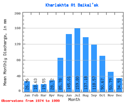
| Statistic | Jan | Feb | Mar | Apr | May | Jun | Jul | Aug | Sep | Oct | Nov | Dec | Annual |
|---|---|---|---|---|---|---|---|---|---|---|---|---|---|
| Mean | 26.92 | 18.83 | 19.47 | 28.73 | 85.77 | 145.08 | 159.74 | 137.17 | 118.55 | 90.61 | 50.79 | 34.94 | 916.63 |
| Standard Deviation | 5.97 | 4.63 | 4.72 | 11.98 | 34.11 | 66.33 | 62.71 | 52.70 | 49.70 | 35.40 | 18.95 | 8.39 | 238.26 |
| Min | 16.29 | 11.87 | 12.48 | 12.96 | 41.62 | 50.79 | 68.76 | 57.90 | 45.53 | 43.43 | 28.02 | 19.90 | 566.87 |
| Max | 38.00 | 28.03 | 28.95 | 56.04 | 161.04 | 311.74 | 316.65 | 293.13 | 210.16 | 186.37 | 105.08 | 48.85 | 1643.75 |
| Coefficient of Variation | 0.22 | 0.25 | 0.24 | 0.42 | 0.40 | 0.46 | 0.39 | 0.38 | 0.42 | 0.39 | 0.37 | 0.24 | 0.26 |
 Return to R-Arctic Net Home Page