|
|
|||||||||||||||||
| Point ID: 6065 | Downloads | Plots | Site Data | Code: 7171 |
|
|
|||||||||||||||||
| Download | |
|---|---|
| Site Descriptor Information | Site Time Series Data |
| Link to all available data | |
| View: | Time Series | All |
| Units: | mm |
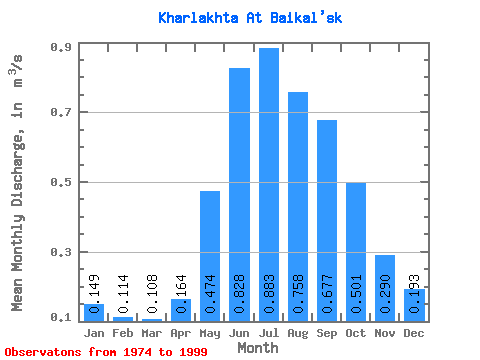
| Statistic | Jan | Feb | Mar | Apr | May | Jun | Jul | Aug | Sep | Oct | Nov | Dec | Annual |
|---|---|---|---|---|---|---|---|---|---|---|---|---|---|
| Mean | 0.15 | 0.11 | 0.11 | 0.16 | 0.47 | 0.83 | 0.88 | 0.76 | 0.68 | 0.50 | 0.29 | 0.19 | 0.43 |
| Standard Deviation | 0.03 | 0.03 | 0.03 | 0.07 | 0.19 | 0.38 | 0.35 | 0.29 | 0.28 | 0.20 | 0.11 | 0.05 | 0.11 |
| Min | 0.09 | 0.07 | 0.07 | 0.07 | 0.23 | 0.29 | 0.38 | 0.32 | 0.26 | 0.24 | 0.16 | 0.11 | 0.27 |
| Max | 0.21 | 0.17 | 0.16 | 0.32 | 0.89 | 1.78 | 1.75 | 1.62 | 1.20 | 1.03 | 0.60 | 0.27 | 0.77 |
| Coefficient of Variation | 0.22 | 0.25 | 0.24 | 0.42 | 0.40 | 0.46 | 0.39 | 0.38 | 0.42 | 0.39 | 0.37 | 0.24 | 0.26 |
 Return to R-Arctic Net Home Page