|
|
|||||||||||||||||
| Point ID: 6065 | Downloads | Plots | Site Data | Code: 7171 |
|
|
|||||||||||||||||
| Download | |
|---|---|
| Site Descriptor Information | Site Time Series Data |
| Link to all available data | |
|
|
| View: | Statistics | Time Series |
| Units: | m3/s |
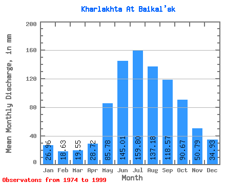
| Statistic | Jan | Feb | Mar | Apr | May | Jun | Jul | Aug | Sep | Oct | Nov | Dec | Annual |
|---|---|---|---|---|---|---|---|---|---|---|---|---|---|
| Mean | 26.92 | 18.83 | 19.47 | 28.73 | 85.77 | 145.08 | 159.74 | 137.17 | 118.55 | 90.61 | 50.79 | 34.94 | 916.63 |
| Standard Deviation | 5.97 | 4.63 | 4.72 | 11.98 | 34.11 | 66.33 | 62.71 | 52.70 | 49.70 | 35.40 | 18.95 | 8.39 | 238.26 |
| Min | 16.29 | 11.87 | 12.48 | 12.96 | 41.62 | 50.79 | 68.76 | 57.90 | 45.53 | 43.43 | 28.02 | 19.90 | 566.87 |
| Max | 38.00 | 28.03 | 28.95 | 56.04 | 161.04 | 311.74 | 316.65 | 293.13 | 210.16 | 186.37 | 105.08 | 48.85 | 1643.75 |
| Coefficient of Variation | 0.22 | 0.25 | 0.24 | 0.42 | 0.40 | 0.46 | 0.39 | 0.38 | 0.42 | 0.39 | 0.37 | 0.24 | 0.26 |
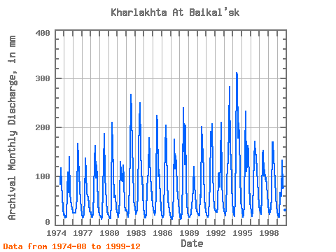
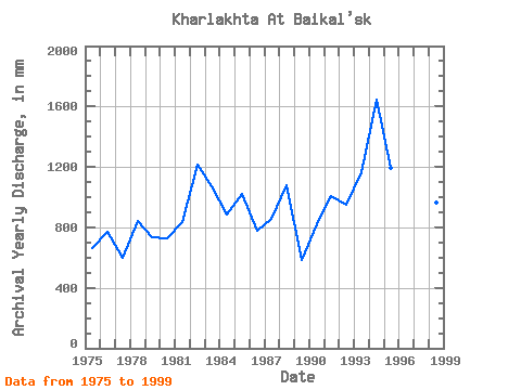
| Year | Jan | Feb | Mar | Apr | May | Jun | Jul | Aug | Sep | Oct | Nov | Dec | Annual | 1974 | 86.85 | 117.34 | 85.05 | 33.28 | 21.71 | 1975 | 23.52 | 14.34 | 19.90 | 16.99 | 72.38 | 108.58 | 68.76 | 144.76 | 63.05 | 54.28 | 38.53 | 38.00 | 659.99 | 1976 | 25.33 | 23.08 | 25.33 | 24.52 | 41.62 | 54.29 | 171.90 | 142.95 | 101.58 | 79.62 | 49.04 | 36.19 | 771.23 | 1977 | 23.52 | 13.52 | 16.65 | 22.77 | 56.09 | 136.60 | 110.38 | 66.95 | 56.04 | 43.43 | 28.02 | 27.14 | 599.57 | 1978 | 27.14 | 15.99 | 17.37 | 22.77 | 72.38 | 131.35 | 168.28 | 99.52 | 122.59 | 99.52 | 40.28 | 30.76 | 844.62 | 1979 | 21.71 | 16.49 | 13.21 | 17.16 | 77.81 | 126.10 | 193.61 | 101.33 | 71.81 | 50.66 | 28.02 | 23.52 | 737.64 | 1980 | 19.90 | 16.32 | 14.66 | 12.96 | 48.85 | 210.16 | 164.66 | 57.90 | 61.30 | 61.52 | 33.28 | 30.76 | 731.07 | 1981 | 23.52 | 16.16 | 28.95 | 52.54 | 133.90 | 108.58 | 94.09 | 92.28 | 122.59 | 97.71 | 40.28 | 30.76 | 838.40 | 1982 | 32.57 | 21.43 | 17.37 | 28.02 | 94.09 | 140.11 | 276.85 | 238.85 | 155.87 | 123.04 | 50.79 | 41.62 | 1213.00 | 1983 | 38.00 | 21.43 | 25.33 | 31.52 | 68.76 | 161.12 | 258.75 | 168.28 | 99.83 | 103.14 | 64.80 | 34.38 | 1069.77 | 1984 | 27.14 | 14.51 | 14.84 | 22.77 | 81.43 | 92.82 | 114.00 | 184.56 | 134.85 | 101.33 | 57.80 | 43.43 | 884.96 | 1985 | 32.57 | 26.38 | 21.71 | 26.27 | 70.57 | 224.17 | 215.33 | 103.14 | 113.84 | 94.09 | 57.80 | 38.00 | 1021.79 | 1986 | 21.71 | 14.34 | 17.01 | 22.77 | 104.95 | 204.91 | 155.61 | 94.09 | 49.04 | 43.43 | 29.77 | 23.52 | 778.52 | 1987 | 16.29 | 12.53 | 12.48 | 22.77 | 74.19 | 175.13 | 119.42 | 146.57 | 124.35 | 79.62 | 45.53 | 30.76 | 857.42 | 1988 | 17.91 | 11.87 | 13.57 | 29.77 | 95.90 | 239.94 | 180.95 | 128.47 | 204.91 | 85.05 | 45.53 | 27.14 | 1079.72 | 1989 | 19.90 | 15.33 | 17.73 | 22.77 | 43.43 | 50.79 | 81.43 | 123.04 | 77.06 | 66.95 | 38.53 | 28.95 | 583.04 | 1990 | 25.33 | 21.43 | 19.90 | 19.27 | 65.14 | 56.04 | 208.09 | 175.52 | 112.09 | 56.09 | 36.78 | 32.57 | 822.76 | 1991 | 21.71 | 18.14 | 17.37 | 21.02 | 54.28 | 82.31 | 197.23 | 180.95 | 206.66 | 115.81 | 59.55 | 39.81 | 1010.42 | 1992 | 32.57 | 24.73 | 27.14 | 35.03 | 106.76 | 106.83 | 81.43 | 139.33 | 210.16 | 90.47 | 54.29 | 41.62 | 948.93 | 1993 | 28.95 | 24.73 | 19.90 | 33.28 | 92.28 | 119.09 | 135.71 | 293.13 | 143.61 | 148.38 | 80.56 | 48.85 | 1162.18 | 1994 | 32.57 | 19.78 | 18.09 | 56.04 | 161.04 | 311.74 | 316.65 | 184.56 | 208.41 | 186.37 | 105.08 | 48.85 | 1643.75 | 1995 | 30.76 | 15.99 | 19.90 | 43.78 | 157.42 | 232.93 | 114.00 | 128.47 | 162.88 | 157.42 | 84.06 | 47.05 | 1191.85 | 1996 | 38.00 | 28.03 | 18.09 | 28.02 | 94.09 | 171.63 | 148.38 | 148.38 | 108.58 | 94.09 | 63.05 | 41.62 | 979.14 | 1997 | 32.57 | 24.73 | 23.52 | 56.04 | 150.19 | 152.37 | 104.95 | 115.81 | 94.57 | 99.52 | 63.05 | 43.43 | 957.82 | 1998 | 30.76 | 21.43 | 28.95 | 33.28 | 57.90 | 169.88 | 175.52 | 141.14 | 113.84 | 92.28 | 61.30 | 38.00 | 961.37 | 1999 | 28.95 | 18.14 | 17.73 | 16.11 | 68.76 | 59.55 | 137.52 | 79.62 | 45.53 | 47.05 | 31.52 | 19.90 | 566.87 |
|---|
 Return to R-Arctic Net Home Page