|
|
|||||||||||||||||
| Point ID: 5942 | Downloads | Plots | Site Data | Other Close Sites | Code: 1594 |
|
|
|||||||||||||||||
| Download | |
|---|---|
| Site Descriptor Information | Site Time Series Data |
| Link to all available data | |
| View: | Time Series | All |
| Units: | m3/s |
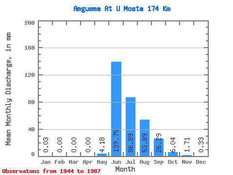
| Statistic | Jan | Feb | Mar | Apr | May | Jun | Jul | Aug | Sep | Oct | Nov | Dec | Annual |
|---|---|---|---|---|---|---|---|---|---|---|---|---|---|
| Mean | 0.03 | 0.00 | 0.00 | 0.00 | 4.18 | 139.75 | 86.88 | 53.88 | 26.29 | 6.03 | 1.71 | 0.33 | 319.60 |
| Standard Deviation | 0.05 | 0.01 | 0.00 | 0.00 | 11.22 | 40.77 | 34.13 | 22.23 | 10.65 | 2.57 | 0.81 | 0.20 | 67.79 |
| Min | 0.00 | 0.00 | 0.00 | 0.00 | 0.00 | 70.89 | 35.50 | 23.74 | 11.49 | 2.59 | 0.43 | 0.01 | 201.41 |
| Max | 0.21 | 0.09 | 0.02 | 0.00 | 61.37 | 251.34 | 165.35 | 130.86 | 49.58 | 13.90 | 4.81 | 0.73 | 507.39 |
| Coefficient of Variation | 1.65 | 5.24 | 6.33 | 6.25 | 2.68 | 0.29 | 0.39 | 0.41 | 0.41 | 0.42 | 0.47 | 0.62 | 0.21 |
| Other Close Sites | ||||||
|---|---|---|---|---|---|---|
| PointID | Latitude | Longitude | Drainage Area | Source | Name | |
| 5914 | "Amguema At Ust'e Shumny" | 67.77 | 2455482 | SHI | ||
 Return to R-Arctic Net Home Page