|
|
|||||||||||||||||
| Point ID: 5942 | Downloads | Plots | Site Data | Other Close Sites | Code: 1594 |
|
|
|||||||||||||||||
| Download | |
|---|---|
| Site Descriptor Information | Site Time Series Data |
| Link to all available data | |
|
|
| View: | Statistics | Time Series |
| Units: | m3/s |
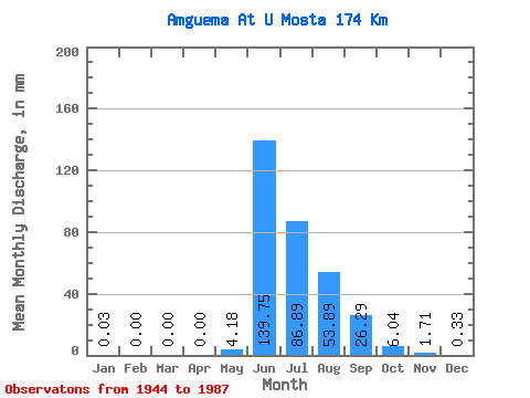
| Statistic | Jan | Feb | Mar | Apr | May | Jun | Jul | Aug | Sep | Oct | Nov | Dec | Annual |
|---|---|---|---|---|---|---|---|---|---|---|---|---|---|
| Mean | 0.03 | 0.00 | 0.00 | 0.00 | 4.18 | 139.75 | 86.88 | 53.88 | 26.29 | 6.03 | 1.71 | 0.33 | 319.60 |
| Standard Deviation | 0.05 | 0.01 | 0.00 | 0.00 | 11.22 | 40.77 | 34.13 | 22.23 | 10.65 | 2.57 | 0.81 | 0.20 | 67.79 |
| Min | 0.00 | 0.00 | 0.00 | 0.00 | 0.00 | 70.89 | 35.50 | 23.74 | 11.49 | 2.59 | 0.43 | 0.01 | 201.41 |
| Max | 0.21 | 0.09 | 0.02 | 0.00 | 61.37 | 251.34 | 165.35 | 130.86 | 49.58 | 13.90 | 4.81 | 0.73 | 507.39 |
| Coefficient of Variation | 1.65 | 5.24 | 6.33 | 6.25 | 2.68 | 0.29 | 0.39 | 0.41 | 0.41 | 0.42 | 0.47 | 0.62 | 0.21 |
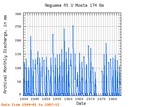
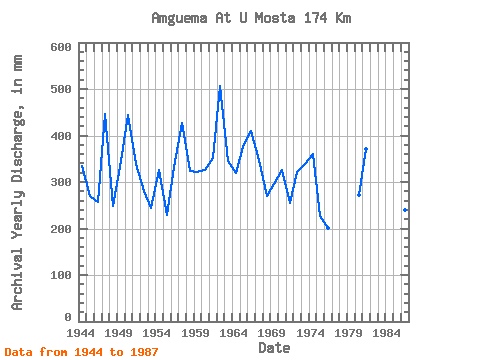
| Year | Jan | Feb | Mar | Apr | May | Jun | Jul | Aug | Sep | Oct | Nov | Dec | Annual | 1944 | 0.03 | 0.00 | 0.00 | 0.00 | 1.51 | 120.76 | 112.60 | 48.89 | 42.32 | 7.21 | 2.23 | 0.34 | 335.27 | 1945 | 0.10 | 0.00 | 0.00 | 0.00 | 0.99 | 132.54 | 66.85 | 39.26 | 16.79 | 10.45 | 1.84 | 0.42 | 269.34 | 1946 | 0.09 | 0.00 | 0.00 | 0.00 | 4.70 | 102.11 | 83.08 | 42.20 | 21.21 | 3.23 | 1.33 | 0.61 | 257.98 | 1947 | 0.04 | 0.00 | 0.00 | 0.00 | 0.11 | 215.02 | 118.68 | 83.18 | 20.82 | 6.86 | 1.20 | 0.10 | 445.73 | 1948 | 0.00 | 0.00 | 0.00 | 0.00 | 12.07 | 129.60 | 46.76 | 40.37 | 14.92 | 3.19 | 1.05 | 0.27 | 248.54 | 1949 | 0.00 | 0.00 | 0.00 | 0.00 | 0.00 | 97.30 | 134.91 | 63.50 | 44.48 | 4.73 | 1.40 | 0.20 | 344.98 | 1950 | 0.03 | 0.00 | 0.00 | 0.00 | 0.00 | 114.87 | 165.35 | 130.86 | 29.36 | 4.88 | 1.52 | 0.61 | 444.20 | 1951 | 0.00 | 0.00 | 0.00 | 0.00 | 0.66 | 135.49 | 101.44 | 80.34 | 16.89 | 4.19 | 1.81 | 0.22 | 339.95 | 1952 | 0.00 | 0.00 | 0.00 | 0.00 | 0.00 | 70.89 | 143.03 | 48.28 | 13.74 | 5.05 | 1.85 | 0.42 | 281.01 | 1953 | 0.01 | 0.00 | 0.00 | 0.00 | 0.00 | 126.66 | 38.55 | 33.78 | 31.91 | 8.79 | 3.43 | 0.59 | 244.61 | 1954 | 0.03 | 0.00 | 0.00 | 0.00 | 0.23 | 139.42 | 69.79 | 53.15 | 49.58 | 9.57 | 3.16 | 0.70 | 326.06 | 1955 | 0.03 | 0.00 | 0.00 | 0.00 | 0.00 | 89.64 | 59.65 | 55.89 | 20.72 | 3.38 | 0.43 | 0.08 | 229.32 | 1956 | 0.01 | 0.00 | 0.00 | 0.00 | 0.01 | 135.49 | 86.63 | 57.11 | 34.27 | 13.90 | 4.81 | 0.04 | 332.00 | 1957 | 0.00 | 0.00 | 0.00 | 0.00 | 0.00 | 219.93 | 87.64 | 92.41 | 21.21 | 3.73 | 1.42 | 0.39 | 426.99 | 1958 | 0.01 | 0.00 | 0.00 | 0.00 | 0.03 | 135.49 | 87.34 | 59.14 | 29.65 | 9.33 | 1.91 | 0.33 | 322.87 | 1959 | 0.00 | 0.00 | 0.00 | 0.00 | 2.97 | 148.25 | 52.04 | 69.49 | 35.34 | 12.48 | 1.45 | 0.23 | 322.51 | 1960 | 0.00 | 0.00 | 0.00 | 0.00 | 0.01 | 150.22 | 67.36 | 75.27 | 27.49 | 4.40 | 1.58 | 0.37 | 326.68 | 1961 | 0.16 | 0.01 | 0.00 | 0.00 | 7.19 | 166.91 | 76.99 | 65.53 | 28.86 | 4.98 | 1.38 | 0.19 | 352.31 | 1962 | 0.00 | 0.00 | 0.00 | 0.00 | 0.12 | 241.53 | 157.23 | 78.62 | 22.68 | 5.88 | 1.47 | 0.30 | 507.39 | 1963 | 0.00 | 0.00 | 0.00 | 0.00 | 0.05 | 157.09 | 107.53 | 47.58 | 26.51 | 5.78 | 1.57 | 0.35 | 346.28 | 1964 | 0.03 | 0.00 | 0.00 | 0.00 | 2.08 | 172.80 | 50.01 | 33.07 | 45.66 | 9.49 | 3.25 | 0.67 | 318.60 | 1965 | 0.01 | 0.00 | 0.00 | 0.00 | 0.00 | 108.00 | 156.22 | 71.21 | 35.15 | 5.23 | 1.32 | 0.35 | 375.42 | 1966 | 0.01 | 0.00 | 0.00 | 0.00 | 0.00 | 251.34 | 93.43 | 41.79 | 18.36 | 2.59 | 0.58 | 0.11 | 409.70 | 1967 | 0.00 | 0.00 | 0.00 | 0.00 | 61.37 | 151.20 | 65.33 | 52.04 | 12.96 | 5.01 | 0.79 | 0.03 | 347.84 | 1968 | 0.00 | 0.00 | 0.00 | 0.00 | 35.20 | 84.83 | 66.75 | 52.95 | 23.46 | 6.06 | 1.30 | 0.06 | 269.32 | 1969 | 0.00 | 0.00 | 0.00 | 0.00 | 3.69 | 154.15 | 80.64 | 23.74 | 27.20 | 4.75 | 1.48 | 0.37 | 296.66 | 1970 | 0.04 | 0.00 | 0.00 | 0.00 | 8.17 | 120.76 | 58.84 | 100.42 | 29.36 | 7.31 | 1.99 | 0.49 | 326.47 | 1971 | 0.21 | 0.01 | 0.00 | 0.00 | 0.00 | 139.42 | 64.11 | 33.88 | 11.49 | 3.35 | 1.40 | 0.24 | 254.52 | 1972 | 0.00 | 0.00 | 0.00 | 0.00 | 1.77 | 111.93 | 111.58 | 48.59 | 42.32 | 3.82 | 2.14 | 0.39 | 321.86 | 1973 | 0.00 | 0.00 | 0.00 | 0.00 | 0.00 | 178.69 | 95.15 | 34.08 | 23.17 | 5.09 | 1.95 | 0.41 | 339.12 | 1974 | 0.00 | 0.00 | 0.00 | 0.00 | 10.55 | 170.84 | 69.39 | 48.89 | 48.01 | 7.91 | 2.38 | 0.73 | 359.47 | 1975 | 0.06 | 0.00 | 0.00 | 0.00 | 0.00 | 100.14 | 65.33 | 30.74 | 23.86 | 6.13 | 1.41 | 0.28 | 227.94 | 1976 | 0.00 | 0.00 | 0.00 | 0.00 | 0.02 | 85.42 | 35.50 | 45.75 | 27.39 | 5.38 | 1.32 | 0.53 | 201.41 | 1979 | 90.58 | 82.88 | 42.81 | 7.63 | 1.46 | 0.03 | 1980 | 0.00 | 0.00 | 0.00 | 0.00 | 0.48 | 149.24 | 72.33 | 31.75 | 12.18 | 5.00 | 0.83 | 0.01 | 272.22 | 1981 | 0.00 | 0.00 | 0.00 | 0.00 | 3.17 | 188.51 | 109.56 | 36.82 | 24.05 | 7.13 | 1.82 | 0.08 | 371.48 | 1982 | 118.80 | 114.63 | 26.68 | 12.47 | 6.89 | 2.04 | 0.33 | 1983 | 0.17 | 0.09 | 0.02 | 130.58 | 78.01 | 39.76 | 13.45 | 5.12 | 1.43 | 0.27 | 1984 | 0.01 | 0.00 | 0.00 | 0.00 | 0.09 | 135.49 | 48.18 | 42.60 | 20.91 | 7.23 | 2.63 | 0.63 | 258.34 | 1985 | 0.12 | 0.00 | 0.00 | 0.00 | 0.13 | 115.86 | 150.13 | 38.85 | 27.20 | 3.71 | 1.13 | 0.52 | 336.30 | 1986 | 0.10 | 0.00 | 0.00 | 0.00 | 1.86 | 127.64 | 46.16 | 38.45 | 19.34 | 3.84 | 1.17 | 0.35 | 239.45 | 1987 | 0.01 | 0.00 | 0.00 | 0.00 | 3.87 | 105.06 | 63.50 | 43.21 | 14.73 | 2.76 | 1.23 | 0.05 | 234.14 |
|---|
| Other Close Sites | ||||||
|---|---|---|---|---|---|---|
| PointID | Latitude | Longitude | Drainage Area | Source | Name | |
| 5914 | "Amguema At Ust'e Shumny" | 67.77 | 2455482 | SHI | ||
 Return to R-Arctic Net Home Page