|
|
|||||||||||||||||
| Point ID: 5914 | Downloads | Plots | Site Data | Other Close Sites | Code: 1492 |
|
|
|||||||||||||||||
| Download | |
|---|---|
| Site Descriptor Information | Site Time Series Data |
| Link to all available data | |
| View: | Time Series | All |
| Units: | m3/s |
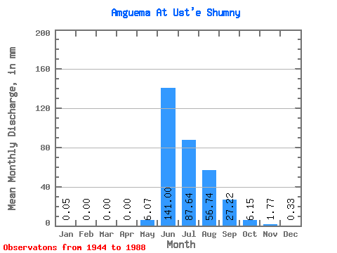
| Statistic | Jan | Feb | Mar | Apr | May | Jun | Jul | Aug | Sep | Oct | Nov | Dec | Annual |
|---|---|---|---|---|---|---|---|---|---|---|---|---|---|
| Mean | 0.05 | 0.00 | 0.00 | 0.00 | 6.07 | 141.00 | 87.63 | 56.73 | 27.22 | 6.15 | 1.77 | 0.33 | 297.94 |
| Standard Deviation | 0.06 | 0.01 | 0.00 | 13.53 | 42.23 | 33.05 | 22.47 | 10.50 | 2.71 | 0.85 | 0.20 | ||
| Min | 0.00 | 0.00 | 0.00 | 0.00 | 0.00 | 70.09 | 38.11 | 23.47 | 11.36 | 2.56 | 0.43 | 0.03 | 297.94 |
| Max | 0.21 | 0.01 | 0.00 | 0.00 | 60.68 | 248.52 | 163.49 | 129.39 | 49.02 | 13.74 | 4.76 | 0.72 | 297.94 |
| Coefficient of Variation | 1.15 | 1.47 | 1.41 | 2.23 | 0.30 | 0.38 | 0.40 | 0.39 | 0.44 | 0.48 | 0.60 |
| Other Close Sites | ||||||
|---|---|---|---|---|---|---|
| PointID | Latitude | Longitude | Drainage Area | Source | Name | |
| 5942 | "Amguema At U mosta 174 km" | 67.70 | 2463450 | SHI | 121.00 | |
 Return to R-Arctic Net Home Page