|
|
|||||||||||||||||
| Point ID: 5914 | Downloads | Plots | Site Data | Other Close Sites | Code: 1492 |
|
|
|||||||||||||||||
| Download | |
|---|---|
| Site Descriptor Information | Site Time Series Data |
| Link to all available data | |
| View: | Time Series | All |
| Units: | mm |
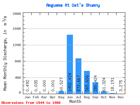
| Statistic | Jan | Feb | Mar | Apr | May | Jun | Jul | Aug | Sep | Oct | Nov | Dec | Annual |
|---|---|---|---|---|---|---|---|---|---|---|---|---|---|
| Mean | 0.49 | 0.04 | 0.00 | 0.00 | 60.53 | 1452.42 | 873.67 | 565.64 | 280.42 | 61.32 | 18.19 | 3.27 | 252.06 |
| Standard Deviation | 0.57 | 0.05 | 0.00 | 134.90 | 435.05 | 329.48 | 224.07 | 108.14 | 26.99 | 8.78 | 1.95 | ||
| Min | 0.00 | 0.00 | 0.00 | 0.00 | 0.00 | 722.00 | 380.00 | 234.00 | 117.00 | 25.50 | 4.42 | 0.25 | 252.06 |
| Max | 2.09 | 0.12 | 0.00 | 0.00 | 605.00 | 2560.00 | 1630.00 | 1290.00 | 505.00 | 137.00 | 49.00 | 7.18 | 252.06 |
| Coefficient of Variation | 1.15 | 1.47 | 1.41 | 2.23 | 0.30 | 0.38 | 0.40 | 0.39 | 0.44 | 0.48 | 0.60 |
| Other Close Sites | ||||||
|---|---|---|---|---|---|---|
| PointID | Latitude | Longitude | Drainage Area | Source | Name | |
| 5942 | "Amguema At U mosta 174 km" | 67.70 | 2463450 | SHI | 121.00 | |
 Return to R-Arctic Net Home Page