|
|
|||||||||||||||||
| Point ID: 586 | Downloads | Plots | Site Data | Code: 07AA007 |
|
|
|||||||||||||||||
| Download | |
|---|---|
| Site Descriptor Information | Site Time Series Data |
| Link to all available data | |
| View: | Time Series | All |
| Units: | m3/s |
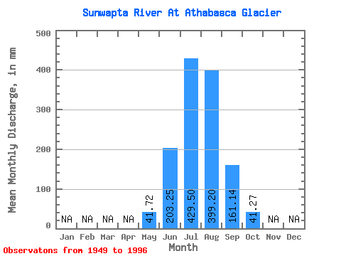
| Statistic | Jan | Feb | Mar | Apr | May | Jun | Jul | Aug | Sep | Oct | Nov | Dec | Annual |
|---|---|---|---|---|---|---|---|---|---|---|---|---|---|
| Mean | 41.72 | 203.25 | 429.47 | 399.10 | 161.13 | 41.24 | |||||||
| Standard Deviation | 31.20 | 71.19 | 90.68 | 89.11 | 62.52 | 19.98 | |||||||
| Min | 9.35 | 88.75 | 149.23 | 255.30 | 51.42 | 9.26 | |||||||
| Max | 152.82 | 355.87 | 578.03 | 578.93 | 343.69 | 95.29 | |||||||
| Coefficient of Variation | 0.75 | 0.35 | 0.21 | 0.22 | 0.39 | 0.48 |
 Return to R-Arctic Net Home Page