|
|
|||||||||||||||||
| Point ID: 586 | Downloads | Plots | Site Data | Code: 07AA007 |
|
|
|||||||||||||||||
| Download | |
|---|---|
| Site Descriptor Information | Site Time Series Data |
| Link to all available data | |
|
|
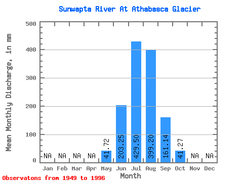
| View: | Statistics | Time Series |
| Units: | m3/s |
| Statistic | Jan | Feb | Mar | Apr | May | Jun | Jul | Aug | Sep | Oct | Nov | Dec | Annual |
|---|---|---|---|---|---|---|---|---|---|---|---|---|---|
| Mean | 41.72 | 203.25 | 429.47 | 399.10 | 161.13 | 41.24 | |||||||
| Standard Deviation | 31.20 | 71.19 | 90.68 | 89.11 | 62.52 | 19.98 | |||||||
| Min | 9.35 | 88.75 | 149.23 | 255.30 | 51.42 | 9.26 | |||||||
| Max | 152.82 | 355.87 | 578.03 | 578.93 | 343.69 | 95.29 | |||||||
| Coefficient of Variation | 0.75 | 0.35 | 0.21 | 0.22 | 0.39 | 0.48 |
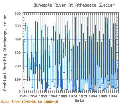
| Year | Jan | Feb | Mar | Apr | May | Jun | Jul | Aug | Sep | Oct | Nov | Dec | Annual | 1949 | 174.89 | 406.33 | 395.54 | 1950 | 534.88 | 414.42 | 198.38 | 1951 | 90.49 | 510.61 | 324.52 | 118.33 | 1952 | 92.23 | 149.23 | 266.99 | 180.98 | 1953 | 175.76 | 442.29 | 418.02 | 163.58 | 41.62 | 1954 | 147.04 | 388.35 | 326.32 | 136.60 | 21.75 | 1955 | 145.31 | 551.06 | 410.82 | 202.73 | 1956 | 36.23 | 247.98 | 540.27 | 457.57 | 191.42 | 1957 | 88.75 | 172.60 | 266.99 | 182.72 | 1958 | 70.75 | 120.07 | 449.48 | 516.90 | 162.71 | 33.35 | 1959 | 160.97 | 426.11 | 277.78 | 103.54 | 1960 | 12.23 | 132.25 | 524.09 | 346.10 | 128.77 | 28.86 | 1961 | 39.55 | 355.87 | 486.34 | 505.21 | 117.46 | 57.62 | 1962 | 187.94 | 366.77 | 363.18 | 116.59 | 31.46 | 1963 | 412.62 | 423.41 | 329.76 | 84.95 | 1964 | 507.01 | 294.86 | 105.28 | 47.38 | 1965 | 212.30 | 410.82 | 533.08 | 51.42 | 31.01 | 1966 | 41.44 | 174.02 | 403.63 | 387.45 | 266.25 | 60.59 | 1967 | 215.78 | 421.61 | 477.35 | 343.69 | 48.00 | 1968 | 16.00 | 168.80 | 409.03 | 311.94 | 167.93 | 34.70 | 1969 | 301.05 | 366.77 | 384.75 | 152.27 | 1970 | 332.38 | 518.70 | 455.77 | 101.80 | 26.79 | 1971 | 26.52 | 174.89 | 361.38 | 548.37 | 130.51 | 45.67 | 1972 | 233.18 | 310.14 | 483.64 | 120.07 | 30.57 | 1973 | 166.19 | 335.31 | 160.97 | 20.41 | 1974 | 13.12 | 176.63 | 339.81 | 376.66 | 151.40 | 55.29 | 1975 | 15.10 | 107.02 | 578.03 | 290.36 | 106.15 | 24.54 | 1976 | 101.80 | 358.69 | 37.40 | 1977 | 19.60 | 246.24 | 329.92 | 391.05 | 77.18 | 9.71 | 1978 | 13.21 | 202.73 | 530.39 | 370.37 | 233.18 | 30.57 | 1979 | 24.90 | 179.24 | 457.57 | 425.21 | 209.69 | 62.03 | 1980 | 83.33 | 221.87 | 395.54 | 255.30 | 126.16 | 67.96 | 1981 | 83.15 | 128.77 | 440.49 | 578.93 | 220.13 | 14.38 | 1982 | 15.64 | 269.73 | 434.20 | 382.06 | 246.24 | 34.97 | 1983 | 37.31 | 226.22 | 385.65 | 439.59 | 88.75 | 24.99 | 1984 | 9.35 | 211.43 | 391.05 | 454.87 | 132.25 | 74.52 | 1985 | 61.49 | 146.18 | 517.80 | 324.52 | 57.51 | 9.26 | 1986 | 76.32 | 336.73 | 347.90 | 392.85 | 108.76 | 30.57 | 1987 | 52.32 | 336.73 | 471.06 | 260.70 | 203.60 | 41.53 | 1988 | 54.93 | 258.42 | 356.89 | 387.45 | 159.23 | 69.04 | 1989 | 18.97 | 225.35 | 451.28 | 377.56 | 112.24 | 28.41 | 1990 | 31.91 | 235.79 | 515.10 | 578.03 | 201.86 | 23.55 | 1991 | 42.25 | 172.28 | 487.24 | 573.54 | 178.37 | 95.29 | 1992 | 65.17 | 342.82 | 409.03 | 365.88 | 105.28 | 67.42 | 1993 | 152.82 | 253.20 | 335.31 | 350.59 | 148.79 | 38.74 | 1994 | 49.44 | 215.78 | 531.28 | 444.09 | 235.79 | 41.98 | 1995 | 33.26 | 274.95 | 533.98 | 292.16 | 201.86 | 36.59 | 1996 | 13.66 | 178.37 | 516.90 | 519.60 | 174.02 | 44.77 |
|---|
 Return to R-Arctic Net Home Page