|
|
|||||||||||||||||
| Point ID: 586 | Downloads | Plots | Site Data | Code: 07AA007 |
|
|
|||||||||||||||||
| Download | |
|---|---|
| Site Descriptor Information | Site Time Series Data |
| Link to all available data | |
| View: | Time Series | All |
| Units: | mm |
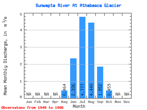
| Statistic | Jan | Feb | Mar | Apr | May | Jun | Jul | Aug | Sep | Oct | Nov | Dec | Annual |
|---|---|---|---|---|---|---|---|---|---|---|---|---|---|
| Mean | 0.46 | 2.34 | 4.78 | 4.44 | 1.85 | 0.46 | |||||||
| Standard Deviation | 0.35 | 0.82 | 1.01 | 0.99 | 0.72 | 0.22 | |||||||
| Min | 0.10 | 1.02 | 1.66 | 2.84 | 0.59 | 0.10 | |||||||
| Max | 1.70 | 4.09 | 6.43 | 6.44 | 3.95 | 1.06 | |||||||
| Coefficient of Variation | 0.75 | 0.35 | 0.21 | 0.22 | 0.39 | 0.48 |
 Return to R-Arctic Net Home Page