|
|
|||||||||||||||||
| Point ID: 5203 | Downloads | Plots | Site Data | Other Close Sites | Code: 05FE001 |
|
|
|||||||||||||||||
| Download | |
|---|---|
| Site Descriptor Information | Site Time Series Data |
| Link to all available data | |
| View: | Time Series | All |
| Units: | m3/s |
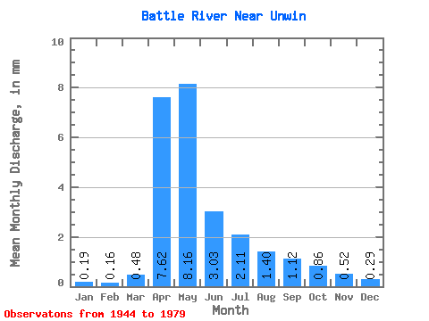
| Statistic | Jan | Feb | Mar | Apr | May | Jun | Jul | Aug | Sep | Oct | Nov | Dec | Annual |
|---|---|---|---|---|---|---|---|---|---|---|---|---|---|
| Mean | 0.08 | 0.07 | 0.21 | 3.33 | 3.57 | 1.32 | 0.92 | 0.61 | 0.49 | 0.38 | 0.23 | 0.13 | 11.39 |
| Standard Deviation | 0.07 | 0.05 | 0.27 | 2.67 | 5.57 | 1.55 | 0.84 | 0.61 | 0.79 | 0.45 | 0.28 | 0.14 | 9.59 |
| Min | 0.00 | 0.00 | 0.00 | 0.36 | 0.38 | 0.19 | 0.11 | 0.05 | 0.03 | 0.04 | 0.05 | 0.02 | 1.87 |
| Max | 0.38 | 0.29 | 1.30 | 9.45 | 27.20 | 6.93 | 3.01 | 2.92 | 4.78 | 2.73 | 1.60 | 0.79 | 50.11 |
| Coefficient of Variation | 0.84 | 0.76 | 1.27 | 0.80 | 1.56 | 1.17 | 0.91 | 0.99 | 1.61 | 1.20 | 1.22 | 1.06 | 0.84 |
| Other Close Sites | ||||||
|---|---|---|---|---|---|---|
| PointID | Latitude | Longitude | Drainage Area | Source | Name | |
| 558 | "BATTLE RIVER NEAR THE SASKATCHEWAN BOUNDARY" | 52.85 | 1388944 | Hydat | ||
 Return to R-Arctic Net Home Page