|
|
|||||||||||||||||
| Point ID: 558 | Downloads | Plots | Site Data | Other Close Sites | Code: 05FE004 |
|
|
|||||||||||||||||
| Download | |
|---|---|
| Site Descriptor Information | Site Time Series Data |
| Link to all available data | |
| View: | Time Series | All |
| Units: | m3/s |
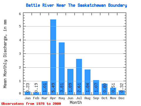
| Statistic | Jan | Feb | Mar | Apr | May | Jun | Jul | Aug | Sep | Oct | Nov | Dec | Annual |
|---|---|---|---|---|---|---|---|---|---|---|---|---|---|
| Mean | 0.10 | 0.08 | 0.44 | 2.41 | 1.67 | 0.83 | 1.15 | 0.81 | 0.47 | 0.35 | 0.23 | 0.14 | 8.83 |
| Standard Deviation | 0.05 | 0.04 | 0.40 | 1.40 | 1.26 | 0.47 | 1.32 | 0.87 | 0.34 | 0.26 | 0.17 | 0.08 | 4.18 |
| Min | 0.03 | 0.03 | 0.04 | 0.64 | 0.37 | 0.12 | 0.15 | 0.10 | 0.04 | 0.08 | 0.04 | 0.04 | 2.57 |
| Max | 0.24 | 0.18 | 1.28 | 5.86 | 5.12 | 1.70 | 5.45 | 3.50 | 1.09 | 1.18 | 0.72 | 0.32 | 17.30 |
| Coefficient of Variation | 0.54 | 0.50 | 0.89 | 0.58 | 0.76 | 0.56 | 1.15 | 1.07 | 0.73 | 0.74 | 0.74 | 0.57 | 0.47 |
| Other Close Sites | ||||||
|---|---|---|---|---|---|---|
| PointID | Latitude | Longitude | Drainage Area | Source | Name | |
| 5203 | "BATTLE RIVER NEAR UNWIN" | 52.94 | 1376396 | Hydat | ||
 Return to R-Arctic Net Home Page