|
|
|||||||||||||||||
| Point ID: 5203 | Downloads | Plots | Site Data | Other Close Sites | Code: 05FE001 |
|
|
|||||||||||||||||
| Download | |
|---|---|
| Site Descriptor Information | Site Time Series Data |
| Link to all available data | |
| View: | Time Series | All |
| Units: | mm |
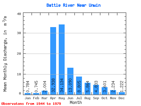
| Statistic | Jan | Feb | Mar | Apr | May | Jun | Jul | Aug | Sep | Oct | Nov | Dec | Annual |
|---|---|---|---|---|---|---|---|---|---|---|---|---|---|
| Mean | 0.78 | 0.74 | 2.00 | 32.94 | 34.13 | 13.09 | 8.80 | 5.86 | 4.83 | 3.60 | 2.23 | 1.22 | 9.24 |
| Standard Deviation | 0.66 | 0.57 | 2.54 | 26.41 | 53.26 | 15.30 | 8.04 | 5.81 | 7.81 | 4.32 | 2.73 | 1.29 | 7.78 |
| Min | 0.04 | 0.01 | 0.02 | 3.54 | 3.59 | 1.87 | 1.05 | 0.45 | 0.27 | 0.42 | 0.45 | 0.19 | 1.52 |
| Max | 3.63 | 3.02 | 12.40 | 93.30 | 260.00 | 68.40 | 28.80 | 27.90 | 47.20 | 26.10 | 15.80 | 7.51 | 40.65 |
| Coefficient of Variation | 0.84 | 0.76 | 1.27 | 0.80 | 1.56 | 1.17 | 0.91 | 0.99 | 1.61 | 1.20 | 1.22 | 1.06 | 0.84 |
| Other Close Sites | ||||||
|---|---|---|---|---|---|---|
| PointID | Latitude | Longitude | Drainage Area | Source | Name | |
| 558 | "BATTLE RIVER NEAR THE SASKATCHEWAN BOUNDARY" | 52.85 | 1388944 | Hydat | ||
 Return to R-Arctic Net Home Page