|
|
|||||||||||||||||
| Point ID: 5183 | Downloads | Plots | Site Data | Code: 03MD001 |
|
|
|||||||||||||||||
| Download | |
|---|---|
| Site Descriptor Information | Site Time Series Data |
| Link to all available data | |
| View: | Time Series | All |
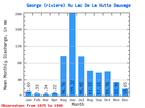
| Units: | m3/s |
| Statistic | Jan | Feb | Mar | Apr | May | Jun | Jul | Aug | Sep | Oct | Nov | Dec | Annual |
|---|---|---|---|---|---|---|---|---|---|---|---|---|---|
| Mean | 11.60 | 7.39 | 6.34 | 8.22 | 96.74 | 199.31 | 95.91 | 61.14 | 57.15 | 59.77 | 33.90 | 18.65 | 658.09 |
| Standard Deviation | 2.92 | 1.97 | 1.84 | 8.07 | 70.99 | 67.83 | 23.77 | 22.18 | 16.02 | 15.53 | 8.68 | 4.49 | 128.85 |
| Min | 6.94 | 4.08 | 3.79 | 3.43 | 15.05 | 104.54 | 49.35 | 32.65 | 25.06 | 31.76 | 20.99 | 12.06 | 454.63 |
| Max | 18.04 | 12.60 | 11.95 | 33.85 | 283.29 | 333.10 | 130.58 | 109.78 | 84.61 | 81.89 | 53.23 | 28.88 | 893.66 |
| Coefficient of Variation | 0.25 | 0.27 | 0.29 | 0.98 | 0.73 | 0.34 | 0.25 | 0.36 | 0.28 | 0.26 | 0.26 | 0.24 | 0.20 |
 Return to R-Arctic Net Home Page