|
|
|||||||||||||||||
| Point ID: 5183 | Downloads | Plots | Site Data | Code: 03MD001 |
|
|
|||||||||||||||||
| Download | |
|---|---|
| Site Descriptor Information | Site Time Series Data |
| Link to all available data | |
| View: | Time Series | All |
| Units: | mm |
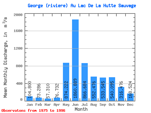
| Statistic | Jan | Feb | Mar | Apr | May | Jun | Jul | Aug | Sep | Oct | Nov | Dec | Annual |
|---|---|---|---|---|---|---|---|---|---|---|---|---|---|
| Mean | 104.80 | 73.29 | 57.31 | 76.73 | 874.22 | 1860.89 | 866.68 | 552.48 | 533.54 | 540.10 | 316.48 | 168.52 | 504.62 |
| Standard Deviation | 26.43 | 19.52 | 16.67 | 75.34 | 641.47 | 633.28 | 214.83 | 200.48 | 149.52 | 140.38 | 81.01 | 40.55 | 98.80 |
| Min | 62.70 | 40.50 | 34.20 | 32.00 | 136.00 | 976.00 | 446.00 | 295.00 | 234.00 | 287.00 | 196.00 | 109.00 | 348.61 |
| Max | 163.00 | 125.00 | 108.00 | 316.00 | 2560.00 | 3110.00 | 1180.00 | 992.00 | 790.00 | 740.00 | 497.00 | 261.00 | 685.25 |
| Coefficient of Variation | 0.25 | 0.27 | 0.29 | 0.98 | 0.73 | 0.34 | 0.25 | 0.36 | 0.28 | 0.26 | 0.26 | 0.24 | 0.20 |
 Return to R-Arctic Net Home Page