|
|
|||||||||||||||||
| Point ID: 5183 | Downloads | Plots | Site Data | Code: 03MD001 |
|
|
|||||||||||||||||
| Download | |
|---|---|
| Site Descriptor Information | Site Time Series Data |
| Link to all available data | |
|
|
| View: | Statistics | Time Series |
| Units: | m3/s |
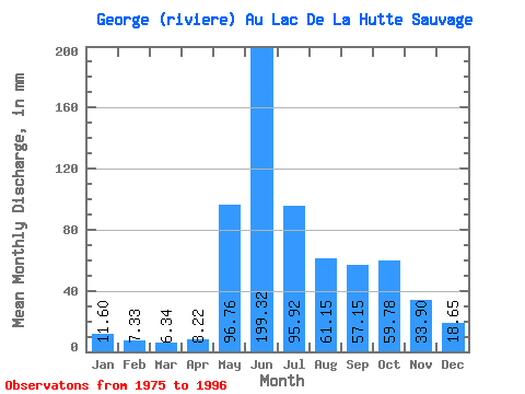
| Statistic | Jan | Feb | Mar | Apr | May | Jun | Jul | Aug | Sep | Oct | Nov | Dec | Annual |
|---|---|---|---|---|---|---|---|---|---|---|---|---|---|
| Mean | 11.60 | 7.39 | 6.34 | 8.22 | 96.74 | 199.31 | 95.91 | 61.14 | 57.15 | 59.77 | 33.90 | 18.65 | 658.09 |
| Standard Deviation | 2.92 | 1.97 | 1.84 | 8.07 | 70.99 | 67.83 | 23.77 | 22.18 | 16.02 | 15.53 | 8.68 | 4.49 | 128.85 |
| Min | 6.94 | 4.08 | 3.79 | 3.43 | 15.05 | 104.54 | 49.35 | 32.65 | 25.06 | 31.76 | 20.99 | 12.06 | 454.63 |
| Max | 18.04 | 12.60 | 11.95 | 33.85 | 283.29 | 333.10 | 130.58 | 109.78 | 84.61 | 81.89 | 53.23 | 28.88 | 893.66 |
| Coefficient of Variation | 0.25 | 0.27 | 0.29 | 0.98 | 0.73 | 0.34 | 0.25 | 0.36 | 0.28 | 0.26 | 0.26 | 0.24 | 0.20 |
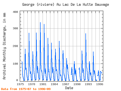
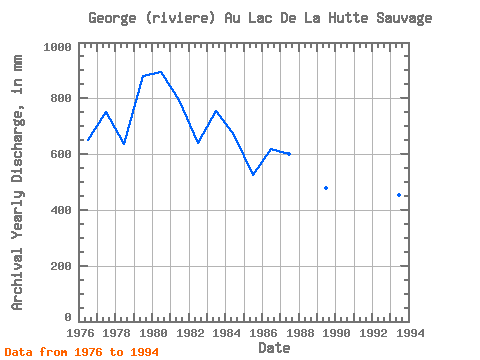
| Year | Jan | Feb | Mar | Apr | May | Jun | Jul | Aug | Sep | Oct | Nov | Dec | Annual | 1975 | 115.09 | 109.78 | 45.20 | 31.76 | 20.99 | 13.28 | 1976 | 9.01 | 6.20 | 5.55 | 4.80 | 127.26 | 183.15 | 72.81 | 67.61 | 74.87 | 52.45 | 28.49 | 19.25 | 649.88 | 1977 | 13.83 | 9.35 | 8.00 | 6.78 | 52.34 | 273.12 | 96.61 | 93.07 | 69.83 | 45.26 | 53.23 | 28.88 | 750.89 | 1978 | 15.49 | 8.65 | 6.44 | 4.69 | 80.23 | 168.16 | 100.48 | 89.75 | 63.62 | 51.46 | 29.99 | 18.81 | 635.85 | 1979 | 13.06 | 9.30 | 8.53 | 7.39 | 283.29 | 196.01 | 91.41 | 48.69 | 84.61 | 72.37 | 44.66 | 26.34 | 881.52 | 1980 | 18.04 | 12.60 | 11.95 | 11.03 | 135.01 | 333.10 | 111.77 | 74.81 | 56.12 | 64.41 | 42.31 | 22.91 | 893.66 | 1981 | 14.83 | 9.74 | 8.28 | 7.05 | 58.76 | 323.46 | 130.58 | 65.40 | 44.56 | 72.70 | 33.74 | 24.23 | 793.37 | 1982 | 15.27 | 9.01 | 6.99 | 5.26 | 42.05 | 244.21 | 115.09 | 54.00 | 68.87 | 44.04 | 23.46 | 13.28 | 642.03 | 1983 | 8.94 | 6.29 | 6.12 | 33.85 | 224.64 | 139.24 | 99.59 | 47.47 | 58.80 | 81.56 | 36.63 | 17.26 | 756.12 | 1984 | 10.44 | 6.50 | 5.92 | 5.45 | 111.77 | 182.08 | 105.46 | 61.86 | 60.41 | 68.17 | 34.38 | 19.59 | 669.80 | 1985 | 11.73 | 7.07 | 5.36 | 3.73 | 20.69 | 227.07 | 79.34 | 49.58 | 32.35 | 38.29 | 30.85 | 18.48 | 525.38 | 1986 | 11.73 | 7.16 | 5.51 | 5.09 | 139.43 | 173.51 | 116.19 | 54.78 | 35.13 | 38.40 | 21.21 | 12.06 | 617.43 | 1987 | 6.94 | 4.08 | 3.79 | 26.88 | 133.90 | 104.54 | 72.26 | 96.05 | 67.37 | 44.26 | 28.49 | 14.61 | 600.16 | 1988 | 8.60 | 5.57 | 41.05 | 65.55 | 81.89 | 35.77 | 15.49 | 1989 | 7.81 | 4.75 | 4.28 | 3.94 | 86.43 | 112.46 | 49.35 | 35.97 | 49.70 | 73.37 | 35.13 | 18.59 | 480.16 | 1990 | 10.21 | 5.73 | 4.21 | 69.62 | 79.79 | 34.60 | 20.47 | 1991 | 13.17 | 7.96 | 5.70 | 3.43 | 22.13 | 172.44 | 102.80 | 51.12 | 63.84 | 72.93 | 37.81 | 17.93 | 570.83 | 1992 | 11.51 | 7.81 | 7.08 | 6.06 | 15.05 | 269.91 | 130.58 | 83.44 | 79.26 | 67.72 | 32.56 | 16.93 | 728.26 | 1993 | 9.85 | 6.13 | 4.95 | 4.37 | 102.25 | 112.46 | 50.13 | 36.85 | 45.73 | 50.46 | 20.99 | 12.06 | 454.63 | 1994 | 8.19 | 5.85 | 5.50 | 4.81 | 49.47 | 167.09 | 75.47 | 40.06 | 61.16 | 60.75 | 38.13 | 21.36 | 537.59 | 1995 | 13.61 | 8.35 | 6.42 | 5.43 | 32.65 | 35.56 | 63.08 | 48.41 | 19.81 | 1996 | 11.29 | 7.07 | 6.26 | 6.12 | 56.66 | 205.65 | 107.23 | 49.91 | 25.06 |
|---|
 Return to R-Arctic Net Home Page