|
|
|||||||||||||||||
| Point ID: 5102 | Downloads | Plots | Site Data | Code: 03CB001 |
|
|
|||||||||||||||||
| Download | |
|---|---|
| Site Descriptor Information | Site Time Series Data |
| Link to all available data | |
| View: | Time Series | All |
| Units: | m3/s |
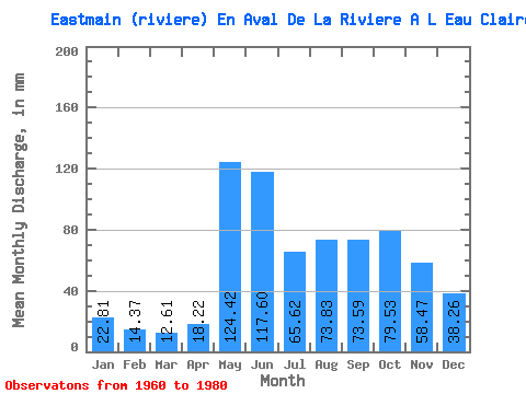
| Statistic | Jan | Feb | Mar | Apr | May | Jun | Jul | Aug | Sep | Oct | Nov | Dec | Annual |
|---|---|---|---|---|---|---|---|---|---|---|---|---|---|
| Mean | 22.80 | 14.49 | 12.61 | 18.21 | 124.40 | 117.60 | 65.61 | 73.82 | 73.59 | 79.52 | 58.47 | 38.26 | 697.09 |
| Standard Deviation | 4.42 | 2.66 | 2.14 | 9.68 | 39.43 | 40.18 | 22.33 | 29.39 | 26.46 | 26.68 | 16.49 | 9.49 | 112.81 |
| Min | 14.21 | 9.87 | 7.71 | 8.35 | 62.36 | 52.78 | 37.90 | 32.10 | 35.47 | 41.19 | 33.87 | 23.30 | 490.04 |
| Max | 33.55 | 21.93 | 17.30 | 42.95 | 201.09 | 236.74 | 127.62 | 127.62 | 148.78 | 145.99 | 106.67 | 58.10 | 879.39 |
| Coefficient of Variation | 0.19 | 0.18 | 0.17 | 0.53 | 0.32 | 0.34 | 0.34 | 0.40 | 0.36 | 0.34 | 0.28 | 0.25 | 0.16 |
 Return to R-Arctic Net Home Page