|
|
|||||||||||||||||
| Point ID: 5102 | Downloads | Plots | Site Data | Code: 03CB001 |
|
|
|||||||||||||||||
| Download | |
|---|---|
| Site Descriptor Information | Site Time Series Data |
| Link to all available data | |
|
|
| View: | Statistics | Time Series |
| Units: | m3/s |
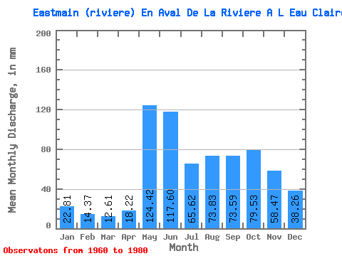
| Statistic | Jan | Feb | Mar | Apr | May | Jun | Jul | Aug | Sep | Oct | Nov | Dec | Annual |
|---|---|---|---|---|---|---|---|---|---|---|---|---|---|
| Mean | 22.80 | 14.49 | 12.61 | 18.21 | 124.40 | 117.60 | 65.61 | 73.82 | 73.59 | 79.52 | 58.47 | 38.26 | 697.09 |
| Standard Deviation | 4.42 | 2.66 | 2.14 | 9.68 | 39.43 | 40.18 | 22.33 | 29.39 | 26.46 | 26.68 | 16.49 | 9.49 | 112.81 |
| Min | 14.21 | 9.87 | 7.71 | 8.35 | 62.36 | 52.78 | 37.90 | 32.10 | 35.47 | 41.19 | 33.87 | 23.30 | 490.04 |
| Max | 33.55 | 21.93 | 17.30 | 42.95 | 201.09 | 236.74 | 127.62 | 127.62 | 148.78 | 145.99 | 106.67 | 58.10 | 879.39 |
| Coefficient of Variation | 0.19 | 0.18 | 0.17 | 0.53 | 0.32 | 0.34 | 0.34 | 0.40 | 0.36 | 0.34 | 0.28 | 0.25 | 0.16 |
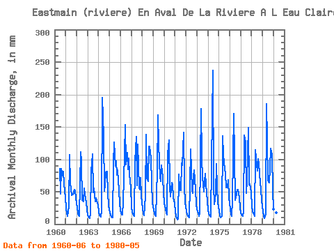
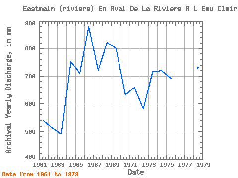
| Year | Jan | Feb | Mar | Apr | May | Jun | Jul | Aug | Sep | Oct | Nov | Dec | Annual | 1960 | 85.90 | 48.44 | 88.85 | 74.67 | 83.72 | 62.23 | 43.31 | 1961 | 24.65 | 15.41 | 12.47 | 27.70 | 110.21 | 64.28 | 46.41 | 47.76 | 45.57 | 54.72 | 50.62 | 41.86 | 539.58 | 1962 | 25.72 | 15.94 | 13.54 | 11.98 | 115.05 | 96.38 | 37.90 | 36.26 | 55.77 | 47.76 | 33.87 | 23.30 | 512.23 | 1963 | 14.21 | 9.87 | 9.49 | 15.53 | 84.30 | 107.61 | 50.27 | 57.43 | 35.47 | 41.19 | 36.12 | 30.07 | 490.04 | 1964 | 19.63 | 12.77 | 11.31 | 20.77 | 201.09 | 134.75 | 52.30 | 62.84 | 79.63 | 83.43 | 47.63 | 29.49 | 752.54 | 1965 | 18.56 | 12.51 | 11.41 | 10.48 | 96.29 | 126.33 | 92.81 | 100.55 | 75.89 | 85.56 | 51.75 | 32.68 | 711.81 | 1966 | 21.46 | 13.83 | 15.08 | 34.34 | 111.18 | 153.46 | 94.45 | 114.08 | 84.50 | 105.38 | 76.64 | 58.10 | 879.39 | 1967 | 28.42 | 16.56 | 13.73 | 12.35 | 100.55 | 134.75 | 62.07 | 127.62 | 56.52 | 55.11 | 71.58 | 44.86 | 721.68 | 1968 | 25.23 | 15.33 | 13.82 | 42.95 | 143.08 | 70.84 | 67.87 | 123.75 | 119.78 | 105.38 | 64.19 | 34.13 | 822.71 | 1969 | 22.53 | 16.03 | 13.82 | 12.63 | 83.72 | 168.43 | 127.62 | 75.31 | 66.62 | 94.26 | 72.15 | 49.60 | 800.30 | 1970 | 33.55 | 21.93 | 17.30 | 14.97 | 113.11 | 130.07 | 58.59 | 43.51 | 63.63 | 62.84 | 41.73 | 32.39 | 632.53 | 1971 | 20.50 | 11.10 | 7.71 | 8.35 | 79.76 | 52.78 | 53.75 | 97.64 | 91.14 | 145.99 | 60.08 | 34.42 | 659.30 | 1972 | 20.98 | 14.09 | 12.28 | 10.57 | 62.36 | 116.03 | 55.40 | 49.69 | 73.36 | 85.66 | 52.87 | 30.36 | 582.78 | 1973 | 23.69 | 15.33 | 12.76 | 16.56 | 183.69 | 102.93 | 73.38 | 51.53 | 64.57 | 80.05 | 60.54 | 35.77 | 717.32 | 1974 | 22.33 | 14.89 | 12.76 | 11.13 | 96.68 | 236.74 | 61.97 | 32.10 | 46.51 | 95.91 | 56.05 | 33.55 | 720.54 | 1975 | 20.01 | 12.86 | 10.93 | 12.26 | 140.18 | 106.67 | 86.91 | 80.44 | 56.71 | 58.30 | 68.59 | 43.31 | 693.86 | 1976 | 23.59 | 14.89 | 12.96 | 36.77 | 175.96 | 104.80 | 38.48 | 47.86 | 53.43 | 55.20 | 40.80 | 25.72 | 628.26 | 1977 | 17.50 | 12.60 | 12.47 | 18.90 | 141.15 | 126.33 | 49.40 | 69.42 | 148.78 | 62.55 | 62.04 | 50.08 | 770.20 | 1978 | 29.49 | 17.97 | 14.89 | 12.54 | 117.95 | 102.00 | 84.59 | 103.45 | 93.11 | 66.52 | 53.24 | 38.77 | 731.56 | 1979 | 19.63 | 11.45 | 9.86 | 15.35 | 191.42 | 131.00 | 69.61 | 66.32 | 86.18 | 120.85 | 106.67 | 53.37 | 878.06 | 1980 | 24.36 | 14.53 | 13.63 | 18.15 | 140.18 |
|---|
 Return to R-Arctic Net Home Page