|
|
|||||||||||||||||
| Point ID: 5102 | Downloads | Plots | Site Data | Code: 03CB001 |
|
|
|||||||||||||||||
| Download | |
|---|---|
| Site Descriptor Information | Site Time Series Data |
| Link to all available data | |
| View: | Time Series | All |
| Units: | mm |
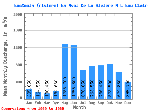
| Statistic | Jan | Feb | Mar | Apr | May | Jun | Jul | Aug | Sep | Oct | Nov | Dec | Annual |
|---|---|---|---|---|---|---|---|---|---|---|---|---|---|
| Mean | 235.85 | 164.55 | 130.45 | 194.66 | 1286.70 | 1256.80 | 678.65 | 763.55 | 786.45 | 822.50 | 624.85 | 395.70 | 611.83 |
| Standard Deviation | 45.77 | 30.23 | 22.13 | 103.43 | 407.84 | 429.37 | 230.99 | 303.96 | 282.73 | 275.94 | 176.24 | 98.17 | 99.01 |
| Min | 147.00 | 112.00 | 79.80 | 89.20 | 645.00 | 564.00 | 392.00 | 332.00 | 379.00 | 426.00 | 362.00 | 241.00 | 430.10 |
| Max | 347.00 | 249.00 | 179.00 | 459.00 | 2080.00 | 2530.00 | 1320.00 | 1320.00 | 1590.00 | 1510.00 | 1140.00 | 601.00 | 771.83 |
| Coefficient of Variation | 0.19 | 0.18 | 0.17 | 0.53 | 0.32 | 0.34 | 0.34 | 0.40 | 0.36 | 0.34 | 0.28 | 0.25 | 0.16 |
 Return to R-Arctic Net Home Page