|
|
|||||||||||||||||
| Point ID: 5091 | Downloads | Plots | Site Data | Code: 03BA003 |
|
|
|||||||||||||||||
| Download | |
|---|---|
| Site Descriptor Information | Site Time Series Data |
| Link to all available data | |
| View: | Time Series | All |
| Units: | m3/s |
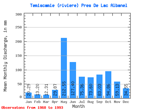
| Statistic | Jan | Feb | Mar | Apr | May | Jun | Jul | Aug | Sep | Oct | Nov | Dec | Annual |
|---|---|---|---|---|---|---|---|---|---|---|---|---|---|
| Mean | 20.29 | 13.31 | 12.31 | 29.87 | 212.51 | 127.40 | 75.35 | 73.59 | 83.03 | 94.85 | 59.13 | 34.55 | 842.37 |
| Standard Deviation | 4.21 | 2.26 | 3.19 | 27.88 | 59.50 | 53.90 | 25.64 | 23.24 | 21.27 | 24.63 | 13.74 | 9.90 | 120.13 |
| Min | 14.53 | 10.09 | 7.87 | 9.93 | 105.94 | 51.63 | 33.51 | 25.79 | 39.88 | 64.38 | 34.39 | 22.04 | 606.92 |
| Max | 30.16 | 18.84 | 25.01 | 140.28 | 321.51 | 285.90 | 155.24 | 126.91 | 119.63 | 157.81 | 86.52 | 60.70 | 1131.19 |
| Coefficient of Variation | 0.21 | 0.17 | 0.26 | 0.93 | 0.28 | 0.42 | 0.34 | 0.32 | 0.26 | 0.26 | 0.23 | 0.29 | 0.14 |
 Return to R-Arctic Net Home Page