|
|
|||||||||||||||||
| Point ID: 5091 | Downloads | Plots | Site Data | Code: 03BA003 |
|
|
|||||||||||||||||
| Download | |
|---|---|
| Site Descriptor Information | Site Time Series Data |
| Link to all available data | |
| View: | Time Series | All |
| Units: | mm |
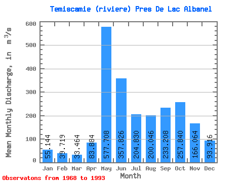
| Statistic | Jan | Feb | Mar | Apr | May | Jun | Jul | Aug | Sep | Oct | Nov | Dec | Annual |
|---|---|---|---|---|---|---|---|---|---|---|---|---|---|
| Mean | 55.14 | 39.72 | 33.46 | 83.88 | 577.71 | 357.83 | 204.83 | 200.05 | 233.21 | 257.84 | 166.06 | 93.92 | 194.31 |
| Standard Deviation | 11.44 | 6.74 | 8.69 | 78.29 | 161.75 | 151.38 | 69.71 | 63.18 | 59.75 | 66.94 | 38.59 | 26.92 | 27.71 |
| Min | 39.50 | 30.10 | 21.40 | 27.90 | 288.00 | 145.00 | 91.10 | 70.10 | 112.00 | 175.00 | 96.60 | 59.90 | 140.00 |
| Max | 82.00 | 56.20 | 68.00 | 394.00 | 874.00 | 803.00 | 422.00 | 345.00 | 336.00 | 429.00 | 243.00 | 165.00 | 260.93 |
| Coefficient of Variation | 0.21 | 0.17 | 0.26 | 0.93 | 0.28 | 0.42 | 0.34 | 0.32 | 0.26 | 0.26 | 0.23 | 0.29 | 0.14 |
 Return to R-Arctic Net Home Page