|
|
|||||||||||||||||
| Point ID: 5091 | Downloads | Plots | Site Data | Code: 03BA003 |
|
|
|||||||||||||||||
| Download | |
|---|---|
| Site Descriptor Information | Site Time Series Data |
| Link to all available data | |
|
|
| View: | Statistics | Time Series |
| Units: | m3/s |
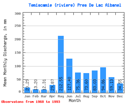
| Statistic | Jan | Feb | Mar | Apr | May | Jun | Jul | Aug | Sep | Oct | Nov | Dec | Annual |
|---|---|---|---|---|---|---|---|---|---|---|---|---|---|
| Mean | 20.29 | 13.31 | 12.31 | 29.87 | 212.51 | 127.40 | 75.35 | 73.59 | 83.03 | 94.85 | 59.13 | 34.55 | 842.37 |
| Standard Deviation | 4.21 | 2.26 | 3.19 | 27.88 | 59.50 | 53.90 | 25.64 | 23.24 | 21.27 | 24.63 | 13.74 | 9.90 | 120.13 |
| Min | 14.53 | 10.09 | 7.87 | 9.93 | 105.94 | 51.63 | 33.51 | 25.79 | 39.88 | 64.38 | 34.39 | 22.04 | 606.92 |
| Max | 30.16 | 18.84 | 25.01 | 140.28 | 321.51 | 285.90 | 155.24 | 126.91 | 119.63 | 157.81 | 86.52 | 60.70 | 1131.19 |
| Coefficient of Variation | 0.21 | 0.17 | 0.26 | 0.93 | 0.28 | 0.42 | 0.34 | 0.32 | 0.26 | 0.26 | 0.23 | 0.29 | 0.14 |
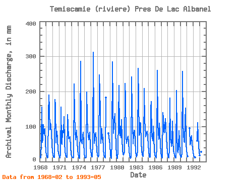
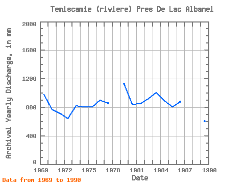
| Year | Jan | Feb | Mar | Apr | May | Jun | Jul | Aug | Sep | Oct | Nov | Dec | Annual | 1968 | 13.57 | 11.26 | 57.32 | 160.02 | 54.83 | 67.69 | 108.89 | 79.04 | 96.38 | 55.90 | 29.43 | 1969 | 20.09 | 13.91 | 11.11 | 11.71 | 138.68 | 190.13 | 155.24 | 94.17 | 109.66 | 107.41 | 79.04 | 50.03 | 977.65 | 1970 | 30.16 | 18.13 | 14.24 | 12.36 | 183.19 | 161.29 | 54.81 | 89.02 | 87.23 | 66.58 | 34.39 | 23.84 | 772.71 | 1971 | 18.32 | 13.11 | 11.26 | 22.11 | 160.39 | 51.63 | 51.50 | 90.86 | 82.25 | 132.43 | 54.12 | 29.46 | 712.66 | 1972 | 19.57 | 13.98 | 13.02 | 12.00 | 138.31 | 106.46 | 67.32 | 69.16 | 70.14 | 73.94 | 40.23 | 22.04 | 643.38 | 1973 | 15.34 | 11.80 | 11.51 | 12.18 | 228.44 | 132.09 | 92.70 | 65.11 | 75.84 | 92.33 | 55.54 | 33.14 | 821.33 | 1974 | 21.70 | 14.08 | 11.77 | 9.93 | 105.94 | 285.90 | 63.27 | 52.97 | 73.70 | 87.18 | 54.48 | 24.32 | 805.98 | 1975 | 14.53 | 10.56 | 11.15 | 12.39 | 205.26 | 127.46 | 91.23 | 77.62 | 63.02 | 69.53 | 84.38 | 42.30 | 805.29 | 1976 | 22.00 | 13.44 | 13.76 | 53.41 | 321.51 | 109.31 | 53.71 | 66.95 | 74.41 | 84.97 | 57.68 | 31.12 | 896.98 | 1977 | 19.86 | 13.98 | 13.65 | 16.45 | 255.66 | 148.47 | 54.44 | 78.35 | 93.28 | 64.38 | 69.78 | 35.98 | 860.82 | 1978 | 20.01 | 13.11 | 11.92 | 10.72 | 188.34 | 83.87 | 60.17 | 49.29 | 1979 | 20.42 | 11.06 | 10.19 | 58.75 | 294.65 | 161.64 | 83.87 | 104.10 | 119.63 | 140.89 | 84.03 | 47.45 | 1131.19 | 1980 | 19.24 | 10.93 | 9.71 | 29.52 | 225.13 | 85.09 | 75.78 | 104.10 | 68.72 | 123.23 | 63.73 | 34.80 | 843.84 | 1981 | 21.89 | 18.84 | 25.01 | 28.16 | 231.01 | 179.80 | 74.67 | 53.34 | 62.31 | 74.31 | 54.12 | 32.37 | 852.87 | 1982 | 18.50 | 11.26 | 9.79 | 13.67 | 250.14 | 143.84 | 110.36 | 52.97 | 79.04 | 92.70 | 86.52 | 60.70 | 924.44 | 1983 | 30.16 | 15.65 | 13.76 | 29.84 | 274.79 | 178.38 | 77.62 | 79.46 | 111.09 | 114.04 | 54.48 | 32.81 | 1007.60 | 1984 | 20.67 | 15.89 | 16.26 | 45.57 | 215.20 | 110.73 | 107.78 | 73.94 | 82.25 | 89.39 | 69.78 | 49.66 | 892.61 | 1985 | 29.50 | 15.85 | 12.21 | 13.21 | 157.44 | 171.61 | 73.57 | 69.89 | 59.46 | 104.10 | 66.94 | 32.92 | 803.92 | 1986 | 18.87 | 12.27 | 11.44 | 43.08 | 268.54 | 107.53 | 86.08 | 66.58 | 109.31 | 85.71 | 47.35 | 27.18 | 879.28 | 1987 | 16.66 | 10.49 | 10.67 | 140.28 | 128.38 | 86.16 | 84.97 | 126.91 | 100.40 | 68.05 | 45.22 | 28.80 | 844.96 | 1988 | 15.45 | 10.96 | 10.85 | 38.45 | 187.24 | 63.02 | 64.74 | 44.51 | 60.17 | 118.82 | 56.61 | 33.70 | 700.06 | 1989 | 20.23 | 13.64 | 10.67 | 10.54 | 209.68 | 73.34 | 33.51 | 25.79 | 39.88 | 90.86 | 59.10 | 23.36 | 606.92 | 1990 | 15.60 | 12.03 | 14.09 | 24.78 | 265.59 | 106.81 | 58.12 | 56.65 | 115.00 | 157.81 | 51.27 | 32.96 | 905.25 | 1991 | 21.70 | 14.58 | 94.71 | 50.03 | 52.97 | 66.22 | 76.88 | 49.49 | 26.78 | 1992 | 18.80 | 12.94 | 10.59 | 12.71 | 61.80 | 110.73 | 75.41 | 43.79 | 29.25 | 1993 | 17.84 | 10.09 | 7.87 | 27.52 | 306.79 |
|---|
 Return to R-Arctic Net Home Page