|
|
|||||||||||||||||
| Point ID: 5083 | Downloads | Plots | Site Data | Code: 03AC002 |
|
|
|||||||||||||||||
| Download | |
|---|---|
| Site Descriptor Information | Site Time Series Data |
| Link to all available data | |
| View: | Time Series | All |
| Units: | m3/s |
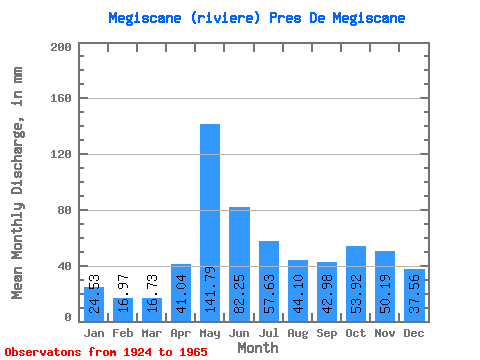
| Statistic | Jan | Feb | Mar | Apr | May | Jun | Jul | Aug | Sep | Oct | Nov | Dec | Annual |
|---|---|---|---|---|---|---|---|---|---|---|---|---|---|
| Mean | 24.52 | 17.12 | 16.73 | 41.04 | 141.77 | 82.25 | 57.62 | 44.09 | 42.98 | 53.91 | 50.19 | 37.55 | 634.46 |
| Standard Deviation | 5.49 | 3.79 | 3.69 | 17.67 | 44.57 | 32.22 | 24.01 | 20.32 | 20.10 | 27.56 | 18.68 | 8.82 | 121.86 |
| Min | 12.50 | 9.63 | 10.25 | 14.19 | 69.61 | 36.18 | 23.78 | 14.15 | 15.66 | 20.24 | 18.25 | 17.05 | 425.29 |
| Max | 37.70 | 24.34 | 26.36 | 92.95 | 258.13 | 148.47 | 117.95 | 85.72 | 97.00 | 174.67 | 90.45 | 55.75 | 945.19 |
| Coefficient of Variation | 0.22 | 0.22 | 0.22 | 0.43 | 0.31 | 0.39 | 0.42 | 0.46 | 0.47 | 0.51 | 0.37 | 0.23 | 0.19 |
 Return to R-Arctic Net Home Page